THE FREE PRESS FOR HUMANITY BY ALEXANDER
MY PRIMARY OBJECTIVE IS TO RELAY ACCURATE DATA PERTAINING TO GLOBAL EVENTS PAST AND PRESENT, AND TO USE THAT DATA EFFECTIVELY TO EDUCATE THE GENERAL PUBLIC ABOUT CONTEMPORARY GLOBAL CHALLENGES; AND POSSIBLE RESOLUTIONS. I HAVE A FIRM BELIEF THAT ALL OF MANKIND IF PROVIDED WITH THE OPPORTUNITY TO LEARN AND GROW, WOULD BE AMAZED BEFORE THEY WERE HALF WAY THROUGH HOW EXCEPTIONAL A FREE GLOBAL EDUCATION COULD BE! THERE ARE NOW SEVEN BILLION POTENTIAL GENIUSES OUT THERE AND FOURTEEN BILLION WORKING HANDS TO SOLVE OUR GLOBAL CRISIS. IF WE LAY DOWN OUR GUNS AND WORK TOGETHER, OUR PLANET, OUR HOME WILL BE AN EXCEPTIONAL PLACE AND TIME IN SUCH A SHORT HUMAN HISTORY. HELP ME TO ACHIEVE THIS GOAL AND BLESS ALL OF YOU FOR MAKING IT THIS FAR WITH SUCH TRIUMPH, AND SUCH TRAGEDY... ENJOY YOUR PASSION FOR LEARNING AGAIN, AND FOR THE DRIVE TO EXPLORE STRANGE NEW WORLDS AND CIVILIZATIONS. TO BOLDLY GO WHERE MANKIND HAS NOT GONE BEFORE!
WARNING CONCERNING CITIES THAT MAY BE DESTROYED.
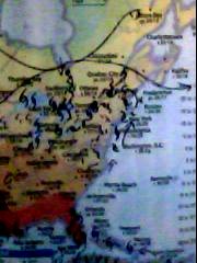
The following Cities, States and provinces must prepare for severe storm damage and or full scale destruction;;;Boston,The State of Maine, Moncton NB, Montreal QC, Ottawa, Toronto, buffalo, Detroit,and Sault Ste Marie The state of Ohio,Eastern Indiana,eastern Michigan, Pennsylvania,, Hamilton Ontario, Ottawa, Good luck, and God bless. http://www.cnn.com/video/#/video/weather/2011/08/27/vo.sc.pier.jump.irene.wral?&hpt=hp_c2
Hurricane Irene and the East Coast...Anyone who cannot get out of the evacuation zones please make it to your nearest stadium{as they are the only structures strong enough to withstand such winds}. @ FEMA- Please ensure there is an adequate emergency water supply at these locations in all affected zones[re:Katrina/ superdome no water for 5 days]. Reroute greyhound busses to assist in facilitating rapid evacuation (relieving traffic congestion on freeways. Good luck, and God bless.
Update time = Wed Aug 24 5:00:06 UTC 2011
MAGUTC DATE-TIME
y/m/d h:m:sLAT
degLON
degDEPTH
km RegionMAP 5.0 2011/08/23 19:53:30 -21.740 -176.850 198.6 FIJI REGIONMAP 5.2 2011/08/23 19:29:53 -5.880 147.476 30.8 EASTERN NEW GUINEA REG, PAPUA NEW GUINEAMAP 4.8 2011/08/23 19:01:51 1.234 120.497 44.9 MINAHASA, SULAWESI, INDONESIAMAP 2.8 2011/08/23 18:46:50 37.931 -77.935 0.1 VIRGINIAMAP 5.8 2011/08/23 17:51:05 37.936 -77.933 6.0 VIRGINIAMAP 4.7 2011/08/23 16:52:05 6.704 -73.039 161.0 NORTHERN COLOMBIAMAP 3.7 2011/08/23 15:34:25 59.074 -151.094 37.1 KENAI PENINSULA, ALASKAMAP 4.8 2011/08/23 14:28:56 36.475 71.236 75.0 HINDU KUSH REGION, AFGHANISTANMAP 3.9 2011/08/23 14:11:13 37.032 -104.690 5.0 COLORADOMAP 2.6 2011/08/23 12:03:56 37.055 -104.761 5.0 COLORADOMAP 3.2 2011/08/23 11:34:56 67.968 -146.118 14.6 NORTHERN ALASKAMAP 3.2 2011/08/23 09:37:58 37.099 -104.711 5.0 COLORADOMAP 2.5 2011/08/23 09:32:22 37.248 -104.705 5.0 COLORADOMAP 2.5 2011/08/23 09:07:35 32.229 -115.353 12.1 BAJA CALIFORNIA, MEXICOMAP 3.8 2011/08/23 07:17:59 37.099 -104.610 4.8 COLORADOMAP 3.0 2011/08/23 07:16:13 39.273 -118.108 10.3 NEVADAMAP 3.2 2011/08/23 07:01:35 37.109 -104.550 5.0 COLORADOMAP 3.5 2011/08/23 06:56:59 37.110 -104.722 5.0 COLORADOMAP 4.8 2011/08/23 06:04:56 42.100 142.480 45.6 HOKKAIDO, JAPAN REGIONMAP 5.3 2011/08/23 05:46:19 37.070 -104.700 4.0 COLORADOMAP 4.9 2011/08/23 04:56:53 12.010 44.041 10.1 NEAR THE COAST OF YEMENMAP 3.6 2011/08/23 04:49:18 19.128 -64.403 68.7 VIRGIN ISLANDS REGIONMAP 4.4 2011/08/23 03:55:57 14.321 -90.055 21.6 GUATEMALAMAP 4.9 2011/08/23 03:20:02 -56.172 -27.076 110.1 SOUTH SANDWICH ISLANDS REGIONMAP 2.9 2011/08/23 03:11:00 59.340 -152.672 75.5 SOUTHERN ALASKAMAP 3.0 2011/08/23 02:48:52 37.056 -104.726 5.0 COLORADOMAP 5.1 2011/08/23 01:23:00 33.155 76.839 41.6 KASHMIR-INDIA BORDER REGIONMAP 2.5 2011/08/23 00:45:48 32.541 -115.720 1.9 BAJA CALIFORNIA, MEXICOMAP 4.6 2011/08/23 00:41:15 -22.071 -179.193 519.8 SOUTH OF THE FIJI ISLANDS MAGUTC DATE-TIME
y/m/d h:m:sLAT
degLON
degDEPTH
km RegionMAP 4.6 2011/08/22 23:30:20 37.050 -104.774 5.0 COLORADOMAP 2.5 2011/08/22 22:38:38 35.510 -97.349 9.4 OKLAHOMA CITY URBAN AREA, OKLAHOMAMAP 4.6 2011/08/22 22:24:54 52.769 -169.840 57.4 FOX ISLANDS, ALEUTIAN ISLANDS, ALASKAMAP 5.0 2011/08/22 22:18:51 -18.291 -177.726 629.6 FIJI REGIONMAP 6.0 2011/08/22 20:12:21 -6.410 103.985 31.3 SOUTHWEST OF SUMATRA, INDONESIAMAP 3.7 2011/08/22 18:42:06 54.567 -160.922 5.0 ALASKA PENINSULAMAP 5.0 2011/08/22 17:39:39 -18.334 168.111 37.1 VANUATUMAP 2.8 2011/08/22 17:02:09 52.222 -170.184 46.2 FOX ISLANDS, ALEUTIAN ISLANDS, ALASKAMAP 4.8 2011/08/22 16:25:22 38.552 69.587 25.4 TAJIKISTANMAP 4.6 2011/08/22 16:02:08 -18.250 -177.966 628.5 FIJI REGIONMAP 4.4 2011/08/22 15:26:11 37.421 141.434 45.0 NEAR THE EAST COAST OF HONSHU, JAPANMAP 4.9 2011/08/22 14:55:32 -7.420 128.126 162.0 KEPULAUAN BARAT DAYA, INDONESIAMAP 2.9 2011/08/22 13:52:35 37.094 -104.709 5.0 COLORADOMAP 2.8 2011/08/22 13:50:41 19.892 -156.046 16.7 HAWAII REGION, HAWAIIMAP 4.6 2011/08/22 12:17:10 36.345 141.578 45.2 NEAR THE EAST COAST OF HONSHU, JAPANMAP 4.8 2011/08/22 12:11:28 36.070 141.742 32.9 NEAR THE EAST COAST OF HONSHU, JAPANMAP 4.0 2011/08/22 11:31:15 56.329 -154.161 88.7 KODIAK ISLAND REGION, ALASKAMAP 5.9 2011/08/22 11:23:39 36.108 141.698 34.5 NEAR THE EAST COAST OF HONSHU, JAPANMAP 3.4 2011/08/22 11:21:24 56.504 -153.947 40.1 KODIAK ISLAND REGION, ALASKAMAP 4.8 2011/08/22 09:55:11 -17.402 167.193 36.8 VANUATUMAP 5.5 2011/08/22 09:38:37 -28.914 -176.565 6.5 KERMADEC ISLANDS REGIONMAP 4.7 2011/08/22 08:36:22 36.019 140.100 71.3 NEAR THE EAST COAST OF HONSHU, JAPANMAP 2.5 2011/08/22 06:05:51 60.376 -151.034 32.9 KENAI PENINSULA, ALASKAMAP 5.8 2011/08/22 06:04:58 -17.471 167.244 34.9 VANUATUMAP 2.5 2011/08/22 05:18:54 52.652 -169.524 4.7 FOX ISLANDS, ALEUTIAN ISLANDS, ALASKAMAP 2.9 2011/08/22 03:11:34 38.288 -118.201 9.6 NEVADAMAP 2.6 2011/08/22 03:01:37 39.483 -119.143 4.4 NEVADAMAP 5.0 2011/08/22 02:52:35 -18.990 167.262 66.9 VANUATUMAP 2.9 2011/08/22 01:49:38 18.885 -67.556 6.0 PUERTO RICO REGIONMAP 4.7 2011/08/22 00:07:09 42.673 143.280 32.3 HOKKAIDO, JAPAN REGION MAGUTC DATE-TIME
y/m/d h:m:sLAT
degLON
degDEPTH
km RegionMAP 2.5 2011/08/21 22:27:02 52.717 -169.541 4.9 FOX ISLANDS, ALEUTIAN ISLANDS, ALASKAMAP 2.9 2011/08/21 22:24:44 52.719 -169.578 4.8 FOX ISLANDS, ALEUTIAN ISLANDS, ALASKAMAP 4.5 2011/08/21 21:39:58 36.845 140.388 54.2 NEAR THE EAST COAST OF HONSHU, JAPANMAP 3.1 2011/08/21 21:21:04 51.714 179.565 4.6 RAT ISLANDS, ALEUTIAN ISLANDS, ALASKAMAP 3.2 2011/08/21 21:21:02 36.438 -121.014 7.5 CENTRAL CALIFORNIAMAP 5.0 2011/08/21 21:14:05 4.731 94.912 39.0 OFF THE WEST COAST OF NORTHERN SUMATRAMAP 4.8 2011/08/21 16:54:21 -7.149 106.889 78.9 JAVA, INDONESIAMAP 3.7 2011/08/21 16:15:05 65.550 -151.783 9.0 NORTHERN ALASKAMAP 2.6 2011/08/21 14:57:44 52.698 -169.649 8.8 FOX ISLANDS, ALEUTIAN ISLANDS, ALASKAMAP 4.4 2011/08/21 14:29:30 -8.001 122.784 207.3 FLORES REGION, INDONESIAMAP 5.8 2011/08/21 13:04:08 -5.577 151.011 40.0 NEW BRITAIN REGION, PAPUA NEW GUINEAMAP 5.6 2011/08/21 12:38:53 -56.391 -27.540 127.7 SOUTH SANDWICH ISLANDS REGIONMAP 4.9 2011/08/21 09:03:50 -18.620 168.083 35.2 VANUATUMAP 2.9 2011/08/21 08:50:07 18.812 -67.590 37.4 PUERTO RICO REGIONMAP 2.5 2011/08/21 08:27:08 18.959 -67.825 24.5 DOMINICAN REPUBLIC REGIONMAP 5.3 2011/08/21 08:18:16 4.702 94.926 35.1 OFF THE WEST COAST OF NORTHERN SUMATRAMAP 2.9 2011/08/21 07:25:00 19.215 -67.780 25.0 DOMINICAN REPUBLIC REGIONMAP 3.4 2011/08/21 06:52:31 58.947 -155.442 101.5 ALASKA PENINSULAMAP 4.8 2011/08/21 06:45:27 -2.196 128.396 35.4 CERAM SEA, INDONESIAMAP 4.3 2011/08/21 06:14:19 37.665 23.215 122.2 SOUTHERN GREECEMAP 4.6 2011/08/21 05:09:26 -27.086 -70.873 25.7 OFFSHORE ATACAMA, CHILEMAP 5.0 2011/08/21 04:44:06 -10.899 162.935 125.5 SOLOMON ISLANDSMAP 2.9 2011/08/21 04:34:22 19.080 -67.803 37.8 DOMINICAN REPUBLIC REGIONMAP 2.9 2011/08/21 03:46:09 18.959 -67.739 24.0 PUERTO RICO REGIONMAP 3.1 2011/08/21 03:33:28 18.590 -67.748 37.9 DOMINICAN REPUBLIC REGIONMAP 4.3 2011/08/21 03:20:23 -19.153 -177.978 487.4 FIJI REGIONMAP 3.0 2011/08/21 03:01:23 18.974 -67.729 17.0 PUERTO RICO REGIONMAP 4.5 2011/08/21 02:31:44 55.189 160.401 4.2 KAMCHATKA PENINSULA, RUSSIAMAP 3.2 2011/08/21 02:22:48 36.369 -117.838 2.3 CENTRAL CALIFORNIAMAP 5.2 2011/08/21 02:09:16 -18.585 168.172 35.7 VANUATUMAP 5.2 2011/08/21 01:24:13 -18.565 168.145 32.9 VANUATUMAP 5.6 2011/08/21 00:23:39 -18.265 167.801 28.8 VANUATUMAP 5.0 2011/08/21 00:09:22 -18.221 167.544 16.2 VANUATU MAGUTC DATE-TIME
y/m/d h:m:sLAT
degLON
degDEPTH
km RegionMAP 5.0 2011/08/20 22:58:42 38.695 141.818 52.2 NEAR THE EAST COAST OF HONSHU, JAPANMAP 2.9 2011/08/20 21:50:20 18.970 -64.710 24.7 VIRGIN ISLANDS REGIONMAP 5.0 2011/08/20 21:38:23 -18.254 168.046 53.8 VANUATUMAP 4.6 2011/08/20 20:24:39 -10.198 109.434 30.6 SOUTH OF JAVA, INDONESIAMAP 4.9 2011/08/20 20:13:42 -18.183 167.743 48.9 VANUATUMAP 4.8 2011/08/20 19:37:23 38.629 141.835 35.4 NEAR THE EAST COAST OF HONSHU, JAPANMAP 5.0 2011/08/20 19:23:04 -18.162 168.110 31.5 VANUATUMAP 2.7 2011/08/20 18:40:56 40.747 -123.938 23.5 NORTHERN CALIFORNIAMAP 7.0 2011/08/20 18:19:25 -18.287 168.132 28.5 VANUATUMAP 5.2 2011/08/20 18:02:01 -18.608 167.910 35.3 VANUATUMAP 5.1 2011/08/20 17:44:27 -18.770 167.924 9.5 VANUATUMAP 4.8 2011/08/20 17:28:52 -20.736 -177.528 371.2 FIJI REGIONMAP 5.9 2011/08/20 17:13:07 -18.287 168.062 37.3 VANUATUMAP 5.6 2011/08/20 17:11:36 -18.289 167.755 40.9 VANUATUMAP 5.0 2011/08/20 17:08:37 -31.402 -178.702 227.9 KERMADEC ISLANDS REGIONMAP 7.1 2011/08/20 16:55:03 -18.260 168.069 40.6 VANUATUMAP 2.5 2011/08/20 15:09:04 55.392 -158.577 24.1 ALASKA PENINSULAMAP 4.9 2011/08/20 14:12:02 36.267 141.865 4.9 NEAR THE EAST COAST OF HONSHU, JAPANMAP 4.7 2011/08/20 12:54:15 51.049 157.194 64.9 NEAR THE EAST COAST OF KAMCHATKA, RUSSIAMAP 4.9 2011/08/20 11:17:19 12.161 140.721 41.8 STATE OF YAP, FED. STATES OF MICRONESIAMAP 5.1 2011/08/20 10:27:16 -15.874 -179.444 2.6 FIJI REGIONMAP 4.6 2011/08/20 10:08:19 -20.915 -179.153 611.1 FIJI REGIONMAP 3.4 2011/08/20 09:58:19 64.013 -146.792 0.5 CENTRAL ALASKAMAP 5.1 2011/08/20 09:50:18 -18.553 168.090 35.1 VANUATUMAP 4.6 2011/08/20 09:38:35 14.863 41.966 9.9 NEAR THE COAST OF ERITREAMAP 2.6 2011/08/20 08:40:38 18.974 -67.685 24.3 PUERTO RICO REGIONMAP 4.7 2011/08/20 07:30:34 -36.862 -73.440 14.1 OFFSHORE BIO-BIO, CHILEMAP 3.2 2011/08/20 06:00:48 52.113 -170.297 25.0 FOX ISLANDS, ALEUTIAN ISLANDS, ALASKAMAP 3.1 2011/08/20 05:39:01 19.203 -64.346 25.0 VIRGIN ISLANDS REGIONMAP 3.1 2011/08/20 05:34:15 18.989 -64.252 62.0 VIRGIN ISLANDS REGIONMAP 5.0 2011/08/20 05:31:23 42.414 71.300 23.4 KYRGYZSTANMAP 3.2 2011/08/20 04:54:33 51.465 -175.603 20.1 ANDREANOF ISLANDS, ALEUTIAN IS., ALASKAMAP 2.7 2011/08/20 04:45:16 18.396 -68.087 107.8 MONA PASSAGE, DOMINICAN REPUBLICMAP 2.9 2011/08/20 03:59:50 63.063 -149.310 86.2 CENTRAL ALASKAMAP 3.1 2011/08/20 03:47:00 18.105 -68.438 90.9 MONA PASSAGE, DOMINICAN REPUBLICMAP 2.7 2011/08/20 03:43:00 61.643 -150.523 0.0 SOUTHERN ALASKAMAP 4.9 2011/08/20 02:00:23 37.973 21.728 8.5 SOUTHERN GREECEMAP 5.2 2011/08/20 01:25:04 -22.561 -174.960 34.2 TONGA REGIONMAP 3.7 2011/08/20 01:10:34 32.166 -115.307 10.0 BAJA CALIFORNIA, MEXICO MAGUTC DATE-TIME
y/m/d h:m:sLAT
degLON
degDEPTH
km RegionMAP 4.9 2011/08/19 23:49:13 36.639 69.846 10.0 HINDU KUSH REGION, AFGHANISTANMAP 4.5 2011/08/19 23:14:12 3.665 128.543 34.8 NORTH OF HALMAHERA, INDONESIAMAP 4.8 2011/08/19 22:04:12 44.535 147.150 85.8 KURIL ISLANDSMAP 2.8 2011/08/19 21:24:30 53.530 -163.715 3.4 UNIMAK ISLAND REGION, ALASKAMAP 3.9 2011/08/19 21:22:41 53.450 -163.667 6.8 UNIMAK ISLAND REGION, ALASKAMAP 5.1 2011/08/19 19:10:12 45.947 142.489 311.6 HOKKAIDO, JAPAN REGIONMAP 3.1 2011/08/19 18:00:38 62.367 -151.212 89.7 CENTRAL ALASKAMAP 3.1 2011/08/19 16:21:36 51.889 -172.120 52.8 ANDREANOF ISLANDS, ALEUTIAN IS., ALASKAMAP 2.5 2011/08/19 15:07:48 52.718 -169.430 4.8 FOX ISLANDS, ALEUTIAN ISLANDS, ALASKAMAP 2.8 2011/08/19 12:47:32 52.630 -169.470 8.5 FOX ISLANDS, ALEUTIAN ISLANDS, ALASKAMAP 3.2 2011/08/19 12:44:14 52.632 -169.483 5.2 FOX ISLANDS, ALEUTIAN ISLANDS, ALASKAMAP 5.3 2011/08/19 11:39:47 46.550 153.246 31.1 KURIL ISLANDSMAP 2.6 2011/08/19 10:03:52 55.880 -161.196 151.4 ALASKA PENINSULAMAP 2.9 2011/08/19 09:40:19 62.346 -151.167 80.8 CENTRAL ALASKAMAP 2.5 2011/08/19 09:00:47 63.293 -151.325 10.5 CENTRAL ALASKAMAP 5.3 2011/08/19 07:48:09 -7.843 123.296 223.1 BANDA SEAMAP 3.2 2011/08/19 06:54:59 48.266 -121.859 12.9 WASHINGTONMAP 6.3 2011/08/19 05:36:33 37.673 141.716 43.6 NEAR THE EAST COAST OF HONSHU, JAPANMAP 4.3 2011/08/19 05:19:13 14.262 -90.129 7.2 GUATEMALAMAP 4.6 2011/08/19 04:51:03 39.224 141.988 32.7 EASTERN HONSHU, JAPANMAP 6.2 2011/08/19 03:54:28 -16.526 -176.905 413.2 FIJI REGIONMAP 5.0 2011/08/19 02:28:51 43.261 146.031 106.3 KURIL ISLANDSMAP 4.3 2011/08/19 00:53:47 13.254 -91.514 35.0 OFFSHORE GUATEMALAMAP 4.6 2011/08/19 00:42:22 37.866 144.419 20.9 OFF THE EAST COAST OF HONSHU, JAPANMAP 2.8 2011/08/19 00:42:13 53.617 -160.653 41.6 SOUTH OF ALASKA MAGUTC DATE-TIME
y/m/d h:m:sLAT
degLON
degDEPTH
km RegionMAP 3.1 2011/08/18 21:43:49 33.773 -118.146 19.6 GREATER LOS ANGELES AREA, CALIFORNIAMAP 2.9 2011/08/18 20:46:20 36.894 -121.624 5.2 CENTRAL CALIFORNIAMAP 2.8 2011/08/18 20:26:14 33.462 -116.471 6.0 SOUTHERN CALIFORNIAMAP 2.9 2011/08/18 19:13:40 52.255 -170.586 26.0 FOX ISLANDS, ALEUTIAN ISLANDS, ALASKAMAP 2.6 2011/08/18 18:36:38 38.218 -118.462 8.4 NEVADAMAP 3.2 2011/08/18 18:16:04 63.620 -149.786 124.6 CENTRAL ALASKAMAP 4.2 2011/08/18 17:50:20 18.745 -68.806 117.0 DOMINICAN REPUBLICMAP 3.0 2011/08/18 16:50:52 34.906 -97.819 9.3 OKLAHOMAMAP 4.6 2011/08/18 16:45:19 37.557 145.142 15.7 OFF THE EAST COAST OF HONSHU, JAPANMAP 3.2 2011/08/18 16:40:00 18.322 -68.475 152.0 MONA PASSAGE, DOMINICAN REPUBLICMAP 4.6 2011/08/18 16:39:43 44.242 145.915 124.2 HOKKAIDO, JAPAN REGIONMAP 2.6 2011/08/18 16:25:50 52.461 -170.328 3.5 FOX ISLANDS, ALEUTIAN ISLANDS, ALASKAMAP 4.6 2011/08/18 15:37:40 51.746 -130.794 10.0 QUEEN CHARLOTTE ISLANDS REGIONMAP 4.5 2011/08/18 15:35:46 51.652 -130.741 10.7 QUEEN CHARLOTTE ISLANDS REGIONMAP 2.5 2011/08/18 14:59:03 32.224 -115.289 15.0 BAJA CALIFORNIA, MEXICOMAP 5.1 2011/08/18 11:57:43 42.618 42.961 10.0 GEORGIA (SAK'ART'VELO)MAP 2.6 2011/08/18 10:56:43 56.452 -156.899 36.2 ALASKA PENINSULAMAP 4.7 2011/08/18 10:34:31 36.033 142.131 32.5 OFF THE EAST COAST OF HONSHU, JAPANMAP 4.6 2011/08/18 10:07:33 -1.966 128.398 51.4 KEPULAUAN OBI, INDONESIAMAP 2.5 2011/08/18 09:58:38 33.662 -119.363 1.0 CHANNEL ISLANDS REGION, CALIFORNIAMAP 4.3 2011/08/18 09:10:58 47.706 147.836 392.4 NORTHWEST OF THE KURIL ISLANDSMAP 2.8 2011/08/18 07:49:45 47.472 -122.046 1.5 SEATTLE-TACOMA URBAN AREA, WASHINGTONMAP 4.1 2011/08/18 06:32:23 15.622 -98.582 9.7 OFFSHORE OAXACA, MEXICOMAP 2.9 2011/08/18 06:09:07 38.724 -118.998 10.7 NEVADAMAP 4.3 2011/08/18 05:54:25 14.285 -90.103 20.5 GUATEMALAMAP 4.6 2011/08/18 05:23:45 -2.977 -79.928 35.5 NEAR THE COAST OF ECUADORMAP 2.9 2011/08/18 05:15:43 18.910 -67.778 31.1 DOMINICAN REPUBLIC REGIONMAP 2.6 2011/08/18 05:07:38 18.133 -67.200 23.3 MONA PASSAGE, PUERTO RICOMAP 3.3 2011/08/18 03:10:13 18.973 -67.647 16.0 PUERTO RICO REGION MAGUTC DATE-TIME
y/m/d h:m:sLAT
degLON
degDEPTH
km RegionMAP 5.2 2011/08/17 23:52:03 36.358 69.403 31.8 HINDU KUSH REGION, AFGHANISTANMAP 2.6 2011/08/17 23:25:07 52.468 -165.036 57.7 SOUTH OF THE ALEUTIAN ISLANDSMAP 3.5 2011/08/17 21:19:50 19.222 -155.494 5.0 ISLAND OF HAWAII, HAWAIIMAP 2.6 2011/08/17 21:09:34 38.435 -118.732 1.3 NEVADAMAP 3.9 2011/08/17 21:04:39 38.445 -118.726 3.6 NEVADAMAP 3.3 2011/08/17 20:32:55 52.080 -171.319 41.4 FOX ISLANDS, ALEUTIAN ISLANDS, ALASKAMAP 2.7 2011/08/17 20:32:37 36.033 -117.769 2.8 CENTRAL CALIFORNIAMAP 2.7 2011/08/17 19:57:20 36.587 -121.182 4.1 CENTRAL CALIFORNIAMAP 2.9 2011/08/17 19:14:19 53.160 -166.857 25.6 FOX ISLANDS, ALEUTIAN ISLANDS, ALASKAMAP 2.7 2011/08/17 18:33:10 57.906 -156.047 126.0 ALASKA PENINSULAMAP 2.9 2011/08/17 17:21:38 53.798 -164.256 42.9 UNIMAK ISLAND REGION, ALASKAMAP 2.5 2011/08/17 17:11:34 32.123 -115.240 15.9 BAJA CALIFORNIA, MEXICOMAP 4.6 2011/08/17 16:32:40 36.206 140.039 89.3 NEAR THE EAST COAST OF HONSHU, JAPANMAP 2.9 2011/08/17 16:09:16 18.946 -67.744 24.0 PUERTO RICO REGIONMAP 3.2 2011/08/17 14:05:44 31.157 -115.674 12.6 BAJA CALIFORNIA, MEXICOMAP 3.0 2011/08/17 13:37:43 18.786 -65.907 60.0 PUERTO RICO REGIONMAP 3.0 2011/08/17 13:27:39 56.090 -153.245 12.6 KODIAK ISLAND REGION, ALASKAMAP 3.0 2011/08/17 13:14:46 19.069 -67.689 29.1 PUERTO RICO REGIONMAP 6.2 2011/08/17 11:44:08 36.776 143.773 10.0 OFF THE EAST COAST OF HONSHU, JAPANMAP 5.4 2011/08/17 10:49:06 -12.269 166.524 35.0 SANTA CRUZ ISLANDSMAP 2.5 2011/08/17 10:26:45 62.867 -143.445 18.0 CENTRAL ALASKAMAP 2.7 2011/08/17 10:21:22 52.123 -171.514 41.6 FOX ISLANDS, ALEUTIAN ISLANDS, ALASKAMAP 2.5 2011/08/17 09:04:53 38.797 -122.734 1.4 NORTHERN CALIFORNIAMAP 2.7 2011/08/17 09:04:19 38.805 -122.778 0.7 NORTHERN CALIFORNIAMAP 3.7 2011/08/17 09:02:51 38.791 -122.748 3.0 NORTHERN CALIFORNIAMAP 2.7 2011/08/17 08:55:26 33.907 -117.783 11.4 GREATER LOS ANGELES AREA, CALIFORNIAMAP 4.8 2011/08/17 08:45:54 35.440 140.809 40.7 NEAR THE EAST COAST OF HONSHU, JAPANMAP 4.8 2011/08/17 08:02:08 5.695 -77.529 44.6 NEAR THE WEST COAST OF COLOMBIAMAP 4.7 2011/08/17 07:55:39 35.413 140.909 36.3 NEAR THE EAST COAST OF HONSHU, JAPANMAP 4.8 2011/08/17 07:37:53 -28.932 -176.364 60.3 KERMADEC ISLANDS REGIONMAP 2.5 2011/08/17 06:50:57 51.587 -177.108 44.9 ANDREANOF ISLANDS, ALEUTIAN IS., ALASKAMAP 3.5 2011/08/17 06:14:17 52.209 -169.307 5.1 FOX ISLANDS, ALEUTIAN ISLANDS, ALASKAMAP 2.6 2011/08/17 05:51:36 53.105 -164.613 26.1 UNIMAK ISLAND REGION, ALASKAMAP 3.1 2011/08/17 05:09:45 31.172 -115.680 10.0 BAJA CALIFORNIA, MEXICO
Nick ol' I tells ya, of chocolate vanilla Mooses! hehehe! MOOOSE!!!THEY HATE PEOPLE MAN!!!!!!! BAAAHAHAHAHAHAHAHAHA!!!!!!!! ;D
Keep Calm And Carry On. :D ! <o)))>< <o)))>< <o)))>< Arthur.


MORE THAN YOU WILL KNOW!!!! :) <O)))>< <O)))>< <O)))>< <O)))>< <O)))>< <O)))><
"You have to understand that there is an element of power in the world, but without values power becomes arbitrary and unmanageable. So you must have both" Henry Kissenger
PLEASE READ "WHAT COLOR IS YOUR PERSONALITY" BY CAROL RITBERGER PH.D. AND SPREAD IT AROUND THE GLOBE LIKE IT WAS THE CURE FOR DIS-EASE AND WAR...http://books.google.com/books/about/What_Color_Is_Your_Personality.html?id=PjvoqCC3iB0C
6.5 Mw - NEAR EAST COAST OF HONSHU, JAPANPreliminary Earthquake ReportMagnitude6.5 MwDate-Time
M-type = Mw; Version = 8Event IDUS c0005gmg
For updates, maps, and technical information, see:
Event Page
or
USGS Earthquake Hazards Program
National Earthquake Information Center
U.S. Geological Survey
http://neic.usgs.gov/
- 19 Aug 2011 05:36:32 UTC
- 19 Aug 2011 14:36:32 near epicenter
- 18 Aug 2011 22:36:32 standard time in your timezone
- 100 km (62 miles) NE (48 degrees) of Iwaki, Honshu, Japan
- 100 km (62 miles) SE (130 degrees) of Sendai, Honshu, Japan
- 113 km (70 miles) E (93 degrees) of Fukushima, Honshu, Japan
- 285 km (177 miles) NE (38 degrees) of TOKYO, Japan
M-type = Mw; Version = 8Event IDUS c0005gmg
For updates, maps, and technical information, see:
Event Page
or
USGS Earthquake Hazards Program
National Earthquake Information Center
U.S. Geological Survey
http://neic.usgs.gov/
FORMAL ADDRESS FROM THE PRESIDENT. 18/08/2011 06:55 AM

It is our civil duty and responsibility as a global family to manage our emotions to the extent that losing our ability to reason does not come as a result. Social programs are supposed to be there to assist in the objective of restoring order and health back into the lives of troubled souls, and emotional balance back into the lives of those who have been imbalanced due to chemical addictions. Don't forget that. And ensure this as a civil requirement when people screw up.5 minutes ago
- Center of Planetary Defense also, with regards to health care, it is also our duty to each other to responsibly prescribe non- narcotic/ non addictive medications only to all patients so as not to turn a patient with a physical ailment into a drug addict (mental dis-ease)3 minutes ago ·http://dotsub.com/view/6474921d-8943-443b-9128-de62aa3b3e54

1a) Start each day with a thank you, to yourself, to your fellows, and to all life known and not.
1b)Be the change you want to see in the world.
1c) Be the love of your life and carry that feeling to all people respectfully and gently.
1d) Never forget to breathe
1e) have the courage to ask for help. This is humility.
1f)accept and give gifts of kindness daily, from the heart seeking no reward other than a warm feeling inside and a magic seen outside.Everywhere.
1G) Whenever feeling grumpy, think of the face of a happy dog, then eat and have a nap.
1h) turn off your phone and electronic devices for a whole day periodically.
1I)Only say and write and act kindnesses to yourself and fellows.
1J) Walk into a heaven you are starting to see.
Blessings, Alexander.
FORMAL ADDRESS FROM THE PRESIDENT OF PLANETARY DEFENSE 7.26.2011
As a friend and keeper, I pray this for you. As your senators deliberate complex and challenging legislative issues, may you be infused with patience, insight, energy, and patience; and as you face relentless pressure from constituents, lobbyists and special interest. May you have the strength to do what is right as you are given the light to see it. Resolving your differences, without rancor or bitterness. May your lives model that of a kingdom lead in a model of compromise that doesn't sacrifice principle, or self respect. Thus preserving values that are ethical, just, and equitable. May you respect each other as I respect you; and may you move forward peacefully, responsibly, and respectfully as a fellow friend and citizen of Earth... As you as a nation have been fused with such great power, so may you be infused with the ethical responsibility ascociated with such. We the People of Earth as a Global family require this of such a great nation. For the American dream was one of opportunity and freedom, but greed threatens to take that away. In your final hours of negotiation, make the right choice, the compassionate choice, the choice that ushers in a new age of forgiveness, compromise,healthy standard of living, and sustainability for All nations under God, and those nations with which whom have diffent Gods or none at all, but who believe in freedom in true peace and co-operation. I am and always shall be your friend until the end., Alexander PMG.-- Alexander PMG.--President of The Center of Planetary Defense. <3 :)
Formal address from the PRESIDENT OF THE CENTER OF PLANETARY DEFENSE
My fellow global citizens, as we the people of Earth reach a state of critical mass as to what we are willing to accept with regards to our unified and Universal rights, freedoms,and economies, at all costs we must remain reasonable, orderly, diplomatic and objective. Transitions take time and change requires individual effort and local effort to serve our fellows within our communities. The path to world peace first begins with ending the internal wars and conflicts within the self and expanding that resolution by example within our respective communities. The path to peace is a great mountain we must all climb, banded together we can do it with the strong helping the weak, the young helping the elderly, and the wealthy providing preferential treatment to the impoverished.
We live not in a world of independence. We live together in a world of inter-dependence and we are all inter-connected. We do not inhabit the Earth we live in cohabitation with all forms of life. My thoughts and prayers are with you all, and I will do my utmost in works and prayer to assist in our preservation, protection, and long term sustainable cohabitation for humanity and all other life...
Walk tall with tolerance and compassion and remember our differences can be the identifying factor we can universally accept in one another. For we all have them. Blessings... President APMG
07.15.2011. After long deliberation, reflection, and careful analysis of what President Obama has brought to the negotiation table; with regards to establishing a long term fiscal accountability package in order to ensure the survival and maintenance of American businesses, jobs, medicare and social programs by raising the debt ceiling and spanning the payment regimen over a larger span of time, while also making the necessary sacrifices regarding reallocation of funds from the Defense budget, and other inflated budgets (in a balanced and fair approach and without sacrificing national security and I will add that increasing the worldwide standard of living IS in fact the most important defense budget we can invest in.) I as Commander and Chief of the Center of Planetary Defense would approve such and endeavor in order to ensure a sustainable future for all trading nations that have economies partially reliant upon the value of the American dollar. Certain assurances would have to be put in place in order to maintain adherence to this New Start plan, regarding lower cost higher quality housing for the poor both local and abroad as a demonstration of adherence to the quality of life and global standard of living act ie: "Marshal Plan enacted June 5 1945."
As the President of the US Stated, "changes are not easy but are necessary for all of us as
individuals to make together. They require compromise, sacrifices,and hard work."
I say too; as our Human civilization faces these Global economic hardships, let us not lose sight of the centuries of hard work that went into building a world of such possibility that we have today. It would be a great tragedy to lose sight of that and let such an amazing opportunity for growth and change slip though our fingers.
Sincerely President Alexander- Center of Planetary Defense.

Some informative videos for you,, have patience and a watch! If you have additional patience, please read as well! Much love, balance, and diplomacy. <3
It is imperative where history is concerned to remember that raising the debt ceiling should not lead to acts of persecution as mentioned by Mr Chomsky. Preferential options for the poor adhere to increasing the standard of living for all, resulting in less risk of rogue acts of desperation by nations under severe socioeconomic conditions..
Observe the intolerant and slightly paranoid stance of the woman interviewing Mr Chomsky. It is quite noticeable when reason and rationality fade away in favor of fear and nationalism. Please watch with balance and objectivity, and try to remember that balance and objectivity as well as listening and capacity for globally respective cohabitation will play the key role in finding peaceful resolutions...
Important TED Talk with regards to coping with Natural Disasters...
THIS JUST IN::::::::::::6.0 Mw - OFFSHORE VALPARAISO, CHILEPreliminary Earthquake ReportMagnitude6.0 MwDate-Time- 16 Jul 2011 00:26:13 UTC
- 15 Jul 2011 20:26:13 near epicenter
- 15 Jul 2011 17:26:13 standard time in your timezone
Location33.798S 72.074WDepth22 kmDistances- 88 km (55 miles) SSW (205 degrees) of Valparaiso, Chile
- 134 km (84 miles) WSW (255 degrees) of SANTIAGO, Chile
- 189 km (118 miles) N (349 degrees) of Talca, Chile
Location UncertaintyHorizontal: 19.8 km; Vertical 7.3 kmParametersNph = 282; Dmin = 134.7 km; Rmss = 0.78 seconds; Gp = 129°
M-type = Mw; Version = 8Event IDUS c0004ymd
For updates, maps, and technical information, see:
Event Page
or
USGS Earthquake Hazards Program
National Earthquake Information Center
U.S. Geological Survey
http://neic.usgs.gov/
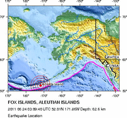
THIS IS THE SECOND MOST RECENT MAJOR EARTHQUAKE..7.4 Mw - FOX ISLANDS, ALEUTIAN ISLANDSPreliminary Earthquake ReportMagnitude7.4 MwDate-Time
- 24 Jun 2011 03:09:39 UTC
- 23 Jun 2011 18:09:39 near epicenter
- 23 Jun 2011 20:09:39 standard time in your timezone
- 163 km (101 miles) E (95 degrees) of Atka, AK
- 225 km (140 miles) WSW (245 degrees) of Nikolski, AK
- 330 km (205 miles) E (85 degrees) of Adak, AK
- 1677 km (1042 miles) WSW (243 degrees) of Anchorage, AK
M-type = Mw; Version = 6Event IDUS c0004f5m
For updates, maps, and technical information, see:
Event Page
or
USGS Earthquake Hazards Program
National Earthquake Information Center
U.S. Geological Survey
http://neic.usgs.gov/
The video below is for your entertainment and laughter. It also provides a good song for reading "boring" seismic data!
THIS JUST IN 21 JUN 20116.1 Mw - SANTA CRUZ ISLANDSPreliminary Earthquake ReportMagnitude6.1 MwDate-Time
- 21 Jun 2011 02:04:15 UTC
- 21 Jun 2011 13:04:15 near epicenter
- 20 Jun 2011 19:04:15 standard time in your timezone
- 412 km (256 miles) ESE (107 degrees) of Kira Kira, Solomon Islands
- 479 km (298 miles) NNW (339 degrees) of Santo (Luganville), Vanuatu
- 653 km (406 miles) ESE (111 degrees) of HONIARA, Solomon Islands
- 2019 km (1254 miles) E (98 degrees) of PORT MORESBY, Papua New Guinea
M-type = Mw; Version = 8Event IDUS c0004clj
For updates, maps, and technical information, see:
Event Page
or
USGS Earthquake Hazards Program
National Earthquake Information Center
U.S. Geological Survey
http://neic.usgs.gov/
Preliminary Earthquake ReportMagnitude6.3 MbDate-Time
M-type = Mb; Version = 4Event IDUS c0004by6
For updates, maps, and technical information, see:
Event Page
or
USGS Earthquake Hazards Program
- 20 Jun 2011 16:35:57 UTC
- 20 Jun 2011 12:35:57 near epicenter
- 20 Jun 2011 09:35:57 standard time in your timezone
- 89 km (55 miles) NE (46 degrees) of Calama, Chile
- 268 km (166 miles) SE (135 degrees) of Iquique, Chile
- 287 km (178 miles) NE (49 degrees) of Antofagasta, Chile
- 1143 km (710 miles) WNW (287 degrees) of ASUNCION, Paraguay
M-type = Mb; Version = 4Event IDUS c0004by6
For updates, maps, and technical information, see:
Event Page
or
USGS Earthquake Hazards Program
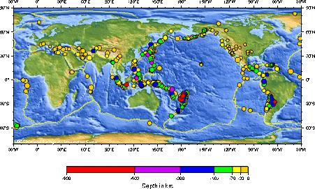
Magnitude 5 and greater earthquakes located by the USGS and contributing networks in the last week (168 hours). Magnitudes 6 and above are in red. (Some early events may be obscured by later ones on the maps.)
The most recent earthquakes are at the top of the list. Times are in Coordinated Universal Time (UTC). Click on the word "map" to see a ten-degree tall map displaying the earthquake. Click on an event's "DATE" to get a detailed report.
DISCLAIMER
Update time = Tue Jun 21 6:00:03 UTC 2011
MAGUTC DATE-TIME
y/m/d h:m:sLAT
degLON
degDEPTH
km RegionMAP 6.1 2011/06/21 02:04:16 -11.510 165.548 13.5 SANTA CRUZ ISLANDSMAP 5.5 2011/06/20 18:13:22 -13.341 167.171 210.7 VANUATUMAP 6.5 2011/06/20 16:36:01 -21.681 -68.187 127.1 ANTOFAGASTA, CHILEMAP 5.3 2011/06/20 10:16:55 25.069 98.707 35.2 MYANMAR-CHINA BORDER REGIONMAP 5.1 2011/06/19 21:26:43 -15.058 -178.029 10.0 FIJI REGIONMAP 5.0 2011/06/19 16:34:43 7.383 -82.201 19.7 SOUTH OF PANAMAMAP 5.5 2011/06/19 08:37:46 -56.128 -27.647 129.8 SOUTH SANDWICH ISLANDS REGIONMAP 5.5 2011/06/19 04:15:58 -3.312 101.338 47.9 SOUTHERN SUMATRA, INDONESIAMAP 5.0 2011/06/19 00:20:07 -5.976 -80.924 30.3 NEAR THE COAST OF NORTHERN PERUMAP 5.5 2011/06/18 20:04:16 -19.324 -175.791 196.5 TONGAMAP 5.2 2011/06/18 11:56:39 -6.319 146.556 50.6 EASTERN NEW GUINEA REG, PAPUA NEW GUINEAMAP 5.9 2011/06/18 11:31:04 37.669 141.638 11.3 NEAR THE EAST COAST OF HONSHU, JAPANMAP 5.1 2011/06/18 05:56:32 -64.358 172.627 15.8 BALLENY ISLANDS REGIONMAP 5.1 2011/06/18 00:58:19 -5.351 145.812 96.5 EASTERN NEW GUINEA REG, PAPUA NEW GUINEAMAP 5.1 2011/06/17 22:08:20 -23.886 69.499 10.0 MID-INDIAN RIDGEMAP 5.3 2011/06/17 10:39:37 48.538 156.248 39.7 EAST OF THE KURIL ISLANDSMAP 5.5 2011/06/17 09:16:13 13.307 41.668 10.0 ERITREA - ETHIOPIA REGIONMAP 5.2 2011/06/17 03:12:16 -6.016 151.152 33.2 NEW BRITAIN REGION, PAPUA NEW GUINEAMAP 5.0 2011/06/17 01:15:34 -7.040 104.636 35.2 SOUTHWEST OF SUMATRA, INDONESIAMAP 5.2 2011/06/16 19:06:05 60.765 -151.048 57.4 KENAI PENINSULA, ALASKAMAP 5.1 2011/06/16 19:00:14 35.330 141.031 22.6 NEAR THE EAST COAST OF HONSHU, JAPANMAP 6.6 2011/06/16 00:03:37 -5.994 151.095 21.5 NEW BRITAIN REGION, PAPUA NEW GUINEAMAP 5.5 2011/06/15 04:41:05 26.795 144.100 14.0 BONIN ISLANDS, JAPAN REGIONMAP 5.3 2011/06/15 01:05:30 27.976 57.574 36.8 SOUTHERN IRANMAP 5.0 2011/06/14 18:27:22 -43.701 173.014 1.0 OFF EAST COAST OF THE SOUTH ISLAND, N.Z.MAP 5.0 2011/06/14 15:54:29 -21.629 169.663 39.3 SOUTHEAST OF THE LOYALTY ISLANDSMAP 5.0 2011/06/14 15:45:08 -21.656 169.596 49.1 SOUTHEAST OF THE LOYALTY ISLANDSMAP 5.2 2011/06/14 14:56:00 39.462 142.359 19.1 NEAR THE EAST COAST OF HONSHU, JAPANMAP 5.8 2011/06/14 13:06:55 37.731 143.486 32.7 OFF THE EAST COAST OF HONSHU, JAPANMAP 5.2 2011/06/14 12:48:55 43.253 145.301 73.8 HOKKAIDO, JAPAN REGIONMAP 5.0 2011/06/14 07:13:07 -5.023 153.306 39.4 NEW IRELAND REGION, PAPUA NEW GUINEA
- Magnitude 6.0 SOUTH ISLAND OF NEW ZEALAND June 13, 2011
- Magnitude 5.8 WESTERN TURKEY May 19, 2011
- Magnitude 5.1 SPAIN May 11, 2011
- Magnitude 6.8 LOYALTY ISLANDS May 10, 2011
- Magnitude 6.9 SOLOMON ISLANDS April 23, 2011
- Magnitude 6.6 EASTERN HONSHU, JAPAN April 11, 2011
- Magnitude 7.1 NEAR THE EAST COAST OF HONSHU, JAPAN April 07, 2011
- Magnitude 6.5 VERACRUZ, MEXICO April 07, 2011
- Magnitude 6.7 SOUTH OF JAVA, INDONESIA April 03, 2011
- Magnitude 6.8 MYANMAR March 24, 2011
- Magnitude 6.6 OFF THE EAST COAST OF HONSHU, JAPAN March 22, 2011
- Magnitude 6.3 VANUATU March 17, 2011
- Magnitude 9.0 NEAR THE EAST COAST OF HONSHU, JAPAN March 11, 2011
- Magnitude 5.4 MYANMAR-CHINA BORDER REGION March 10, 2011
- Magnitude 6.5 NEW BRITAIN REGION, PAPUA NEW GUINEA March 09, 2011
- Magnitude 7.2 NEAR THE EAST COAST OF HONSHU, JAPAN March 09, 2011
- Magnitude 6.6 SOLOMON ISLANDS March 07, 2011
- Magnitude 6.5 SOUTH SANDWICH ISLANDS REGION March 06, 2011
- Magnitude 4.7 ARKANSAS February 28, 2011
- Magnitude 6.1 SOUTH ISLAND OF NEW ZEALAND February 21, 2011
- Magnitude 4.1 ARKANSAS February 18, 2011
- Magnitude 6.6 OFFSHORE MAULE, CHILE February 14, 2011
- Magnitude 6.8 OFFSHORE BIO-BIO, CHILE February 11, 2011
- Magnitude 6.5 CELEBES SEA February 10, 2011
- Magnitude 7.2 SOUTHWESTERN PAKISTAN January 18, 2011
- Magnitude 7.0 LOYALTY ISLANDS January 13, 2011
- Magnitude 6.6 VANUATU January 09, 2011
- Magnitude 4.1 NORTHERN CALIFORNIA January 08, 2011
- Magnitude 7.1 ARAUCANIA, CHILE January 02, 2011
- Magnitude 7.0 SANTIAGO DEL ESTERO, ARGENTINA January 01, 2011
Current Time: Tue, 21 Jun 2011 06:34:45 UTC
DATE-(UTC)-TIME
yyyy/mm/dd hh:mm:ssLatitude
degreesLongitude
degreesDepth
kmMagnitudeComments2011/06/13 18:47:4456.11S27.43W1075.3SOUTH SANDWICH ISLANDS REGION2011/06/13 16:49:4936.70N141.94E334.9NEAR THE EAST COAST OF HONSHU, JAPAN2011/06/13 15:46:358.05S110.72E1524.7JAVA, INDONESIA2011/06/13 14:31:212.53N126.44E526.4MOLUCCA SEA2011/06/13 14:01:2637.47N144.08E104.7OFF THE EAST COAST OF HONSHU, JAPAN2011/06/13 13:09:2138.62N143.25E104.6OFF THE EAST COAST OF HONSHU, JAPAN2011/06/13 13:08:4543.71N122.57E164.9EASTERN NEI MONGOL, CHINA2011/06/13 12:46:0019.18S177.49W5645.4FIJI REGION2011/06/13 12:04:049.17S122.98E874.6SAVU SEA2011/06/13 08:40:190.25S119.92E84.7MINAHASA, SULAWESI, INDONESIA2011/06/13 06:50:3239.98N143.03E245.0OFF THE EAST COAST OF HONSHU, JAPAN2011/06/13 06:38:4215.84S173.17W264.8TONGA2011/06/13 05:50:5243.25N139.14E2124.2EASTERN SEA OF JAPAN2011/06/13 05:19:5632.39S71.08W494.7VALPARAISO, CHILE2011/06/13 02:55:2839.82N143.46E204.4OFF THE EAST COAST OF HONSHU, JAPAN2011/06/13 02:40:3043.52S172.81E144.6SOUTH ISLAND OF NEW ZEALAND2011/06/13 02:20:4943.58S172.74E95.9SOUTH ISLAND OF NEW ZEALAND2011/06/13 02:15:2336.43N71.28E2084.3HINDU KUSH REGION, AFGHANISTAN2011/06/13 01:01:0043.51S172.80E105.2SOUTH ISLAND OF NEW ZEALAND2011/06/13 00:29:4443.36S172.15E114.3SOUTH ISLAND OF NEW ZEALAND2011/06/13 00:25:2839.91N143.42E244.7OFF THE EAST COAST OF HONSHU, JAPAN2011/06/13 00:02:3660.49S56.47W104.8SOUTH SHETLAND ISLANDS 2011/06/12 23:24:4721.28S70.47W524.7OFFSHORE ANTOFAGASTA, CHILE2011/06/12 21:41:5713.30N41.66E154.6ERITREA - ETHIOPIA REGION2011/06/12 21:37:1413.23N41.80E154.5ERITREA - ETHIOPIA REGION2011/06/12 21:03:2313.53N41.62E105.7ERITREA - ETHIOPIA REGION2011/06/12 20:48:1628.10N129.95E205.0RYUKYU ISLANDS, JAPAN2011/06/12 20:32:4013.46N41.68E105.7ERITREA - ETHIOPIA REGION2011/06/12 20:32:278.47S74.78W1444.7CENTRAL PERU2011/06/12 19:52:304.69S143.71E1044.9NEW GUINEA, PAPUA NEW GUINEA2011/06/12 19:44:1613.36N41.64E104.8ERITREA - ETHIOPIA REGION2011/06/12 19:37:4213.31N41.61E104.7ERITREA - ETHIOPIA REGION2011/06/12 19:21:4512.47N41.74E105.0ETHIOPIA2011/06/12 18:01:1912.81N41.93E104.5ETHIOPIA2011/06/12 17:47:2013.53N41.58E104.7ERITREA - ETHIOPIA REGION2011/06/12 17:18:0913.38N41.76E104.8ERITREA - ETHIOPIA REGION2011/06/12 16:51:4832.23N97.00W52.7NORTHERN TEXAS2011/06/12 16:33:1113.50N41.72E104.3ERITREA - ETHIOPIA REGION2011/06/12 16:24:4413.43N41.68E104.8ERITREA - ETHIOPIA REGION2011/06/12 16:12:0213.39N41.73E104.7ERITREA - ETHIOPIA REGION2011/06/12 16:09:3013.44N41.69E34.5ERITREA - ETHIOPIA REGION2011/06/12 15:37:0513.45N41.68E105.1ERITREA - ETHIOPIA REGION2011/06/12 14:51:5617.02N121.76E294.4LUZON, PHILIPPINES2011/06/12 14:30:494.34S122.80E324.7SULAWESI, INDONESIA2011/06/12 12:57:5736.17N141.54E354.9NEAR THE EAST COAST OF HONSHU, JAPAN2011/06/12 11:56:0356.15S27.35W1014.9SOUTH SANDWICH ISLANDS REGION2011/06/12 11:17:4717.31N94.89W1324.6VERACRUZ, MEXICO2011/06/12 11:16:3756.26N164.20E235.2KOMANDORSKIYE OSTROVA, RUSSIA REGION2011/06/12 10:17:5612.78N88.49W884.8OFFSHORE EL SALVADOR2011/06/12 09:06:3641.85N125.68W242.9OFF THE COAST OF NORTHERN CALIFORNIA2011/06/12 08:09:4736.37N141.00E444.9NEAR THE EAST COAST OF HONSHU, JAPAN2011/06/12 06:34:406.09S148.92E844.9NEW BRITAIN REGION, PAPUA NEW GUINEA2011/06/12 06:24:103.96N126.31E364.7KEPULAUAN TALAUD, INDONESIA2011/06/12 05:24:2514.32S171.32E6115.3VANUATU REGION2011/06/12 03:30:5125.62S176.63W214.8SOUTH OF THE FIJI ISLANDS2011/06/12 01:30:411.85N127.42E754.7HALMAHERA, INDONESIA2011/06/12 00:38:0235.78N140.55E354.7NEAR THE EAST COAST OF HONSHU, JAPAN 2011/06/11 22:23:3512.72N88.40W954.7OFFSHORE EL SALVADOR2011/06/11 21:08:4638.35N122.56W103.1NORTHERN CALIFORNIA2011/06/11 20:23:086.63S106.41E104.6JAVA, INDONESIA2011/06/11 20:20:5662.08N149.32W292.7CENTRAL ALASKA2011/06/11 20:08:5737.03N141.34E154.6NEAR THE EAST COAST OF HONSHU, JAPAN2011/06/11 19:17:496.78S129.36E194.7BANDA SEA2011/06/11 19:00:026.76S129.31E374.4BANDA SEA2011/06/11 18:51:5715.47N104.80W134.3OFF THE COAST OF MICHOACAN, MEXICO2011/06/11 18:41:576.94S150.52E24.9NEW BRITAIN REGION, PAPUA NEW GUINEA2011/06/11 17:19:4532.32N115.22W83.4BAJA CALIFORNIA, MEXICO2011/06/11 16:31:2039.72N143.14E334.8OFF THE EAST COAST OF HONSHU, JAPAN2011/06/11 16:26:3650.43N159.34E444.7EAST OF THE KURIL ISLANDS2011/06/11 14:02:4338.02N144.67E384.7OFF THE EAST COAST OF HONSHU, JAPAN2011/06/11 11:21:5258.26S14.04W105.3EAST OF THE SOUTH SANDWICH ISLANDS2011/06/11 11:16:0019.40N155.49W102.9ISLAND OF HAWAII, HAWAII2011/06/11 09:05:0137.58N142.68E244.6OFF THE EAST COAST OF HONSHU, JAPAN2011/06/11 08:17:4833.62N119.04W113.5CHANNEL ISLANDS REGION, CALIFORNIA2011/06/11 04:17:0135.31N141.15E224.7NEAR THE EAST COAST OF HONSHU, JAPAN2011/06/11 03:00:5239.54N143.26E294.4OFF THE EAST COAST OF HONSHU, JAPAN 2011/06/10 22:35:5538.33N142.14E315.1NEAR THE EAST COAST OF HONSHU, JAPAN2011/06/10 19:41:1816.15N98.37W134.5OFFSHORE OAXACA, MEXICO2011/06/10 19:07:115.60S151.83E604.6NEW BRITAIN REGION, PAPUA NEW GUINEA2011/06/10 18:33:2436.73N142.13E354.8OFF THE EAST COAST OF HONSHU, JAPAN2011/06/10 18:15:5851.24N165.24W403.2SOUTH OF THE ALEUTIAN ISLANDS2011/06/10 17:28:0532.27N115.33W43.3BAJA CALIFORNIA, MEXICO2011/06/10 15:32:496.68S122.72W105.3SOUTH PACIFIC OCEAN2011/06/10 14:45:2623.94S69.39W794.9ANTOFAGASTA, CHILE2011/06/10 14:31:0214.90S171.05E6554.8VANUATU REGION2011/06/10 13:42:287.37S156.18E584.8SOLOMON ISLANDS2011/06/10 13:39:4538.69N141.75E474.8NEAR THE EAST COAST OF HONSHU, JAPAN2011/06/10 13:13:2616.42N98.32W144.7GUERRERO, MEXICO2011/06/10 08:28:137.08S39.61E104.8TANZANIA2011/06/10 08:18:3536.40N140.76E354.5NEAR THE EAST COAST OF HONSHU, JAPAN2011/06/10 06:31:1053.44N165.40W262.8FOX ISLANDS, ALEUTIAN ISLANDS, ALASKA2011/06/10 04:55:4026.25S70.58W264.5ATACAMA, CHILE2011/06/10 04:44:4013.89N91.36W683.8OFFSHORE GUATEMALA2011/06/10 02:38:0536.20N73.08E574.6NORTHWESTERN KASHMIR2011/06/10 01:25:2123.53N121.60E294.5TAIWAN2011/06/10 01:13:3314.49N146.68E534.6ROTA REGION, NORTHERN MARIANA ISLANDS2011/06/10 00:58:596.74S150.42E385.2NEW BRITAIN REGION, PAPUA NEW GUINEA2011/06/10 00:38:5260.08N152.87W1102.6SOUTHERN ALASKA2011/06/10 00:11:236.64S147.89E575.2EASTERN NEW GUINEA REG, PAPUA NEW GUINEA 2011/06/09 23:04:0639.31S72.70W1134.7ARAUCANIA, CHILE2011/06/09 20:16:3030.36S177.92W475.6KERMADEC ISLANDS, NEW ZEALAND2011/06/09 16:16:3340.71N19.86E74.4ALBANIA2011/06/09 15:40:5737.90N141.53E544.7NEAR THE EAST COAST OF HONSHU, JAPAN2011/06/09 15:22:1232.66N115.73W154.5SOUTHERN CALIFORNIA2011/06/09 12:09:493.54S150.56E394.8NEW IRELAND REGION, PAPUA NEW GUINEA2011/06/09 10:38:3336.40N140.84E115.4NEAR THE EAST COAST OF HONSHU, JAPAN2011/06/09 10:26:0637.26N142.14E215.1OFF THE EAST COAST OF HONSHU, JAPAN2011/06/09 10:13:1632.20N49.97E364.8WESTERN IRAN2011/06/09 09:51:0314.14N92.89E395.0ANDAMAN ISLANDS, INDIA REGION2011/06/09 07:40:3059.58N152.42W714.0SOUTHERN ALASKA2011/06/09 07:34:2623.58N89.73E144.4BANGLADESH2011/06/09 07:12:0444.20N147.69E904.8KURIL ISLANDS2011/06/09 04:31:2538.41N144.12E104.5OFF THE EAST COAST OF HONSHU, JAPAN2011/06/09 03:28:3555.60S29.18W354.7SOUTH SANDWICH ISLANDS REGION2011/06/09 03:21:0720.32S168.31E264.8LOYALTY ISLANDS2011/06/09 00:12:0725.06N125.90E414.7SOUTHWESTERN RYUKYU ISLANDS, JAPAN 2011/06/08 22:27:4720.26S168.21E595.0LOYALTY ISLANDS2011/06/08 22:11:1739.06N142.35E405.0NEAR THE EAST COAST OF HONSHU, JAPAN2011/06/08 21:46:0420.33S168.34E475.3LOYALTY ISLANDS2011/06/08 21:07:2623.05S174.52W274.8TONGA REGION2011/06/08 16:56:1332.05N115.03W102.8BAJA CALIFORNIA, MEXICO2011/06/08 16:32:181.17N96.77E215.3NIAS REGION, INDONESIA2011/06/08 15:40:144.56S149.93E5105.3BISMARCK SEA2011/06/08 10:53:0316.39S69.79W1914.4SOUTHERN PERU2011/06/08 08:48:505.18S102.43E454.7SOUTHERN SUMATRA, INDONESIA2011/06/08 07:53:4541.45N142.45E264.7HOKKAIDO, JAPAN REGION2011/06/08 06:35:205.06N82.53W264.6SOUTH OF PANAMA2011/06/08 04:41:3433.97S72.10W275.0OFFSHORE LIBERTADOR O HIGGINS, CHILE2011/06/08 04:27:4620.27S168.31E105.4LOYALTY ISLANDS2011/06/08 03:55:5321.37S68.03W1084.6POTOSI, BOLIVIA2011/06/08 03:06:2316.92S69.42W1465.9SOUTHERN PERU2011/06/08 03:05:0242.96N88.65E234.8NORTHERN XINJIANG, CHINA2011/06/08 02:29:4317.76N40.27E104.2RED SEA2011/06/08 01:53:2643.01N88.24E225.3NORTHERN XINJIANG, CHINA2011/06/08 01:18:5311.54S13.12W104.6ASCENSION ISLAND REGION 2011/06/07 20:51:3511.25N86.66W794.3NEAR THE COAST OF NICARAGUA2011/06/07 16:30:1034.10N117.27W113.0GREATER LOS ANGELES AREA, CALIFORNIA2011/06/07 14:55:2015.35N93.07W765.3CHIAPAS, MEXICO2011/06/07 10:53:491.31N97.04E344.6NIAS REGION, INDONESIA2011/06/07 10:38:3048.32N154.24E585.3KURIL ISLANDS2011/06/07 09:32:2428.16S112.92W104.9EASTER ISLAND REGION2011/06/07 09:08:3432.76N71.80E404.7PAKISTAN2011/06/07 08:52:0917.84S178.44W5014.7FIJI REGION2011/06/07 08:33:5910.46N126.26E664.5PHILIPPINE ISLANDS REGION2011/06/07 08:10:3638.07N90.90W213.9MISSOURI2011/06/07 07:31:5941.99N125.81W52.9OFF THE COAST OF NORTHERN CALIFORNIA2011/06/07 05:18:3244.18S16.12W105.6SOUTHERN MID-ATLANTIC RIDGE2011/06/07 05:11:1344.05S15.93W105.4SOUTHERN MID-ATLANTIC RIDGE2011/06/07 03:52:3140.31N143.32E264.7OFF THE EAST COAST OF HONSHU, JAPAN2011/06/07 03:27:411.20N96.93E604.6NIAS REGION, INDONESIA2011/06/07 02:54:241.19N96.76E435.0NIAS REGION, INDONESIA2011/06/07 01:07:0834.49S72.14W264.5OFFSHORE LIBERTADOR O HIGGINS, CHILE2011/06/07 01:06:4236.97N142.04E444.8OFF THE EAST COAST OF HONSHU, JAPAN2011/06/07 00:39:293.74S145.77E365.0NEAR NORTH COAST OF NEW GUINEA, P.N.G. 2011/06/06 23:07:115.58N126.48E924.6MINDANAO, PHILIPPINES2011/06/06 20:10:2737.75N141.49E464.9NEAR THE EAST COAST OF HONSHU, JAPAN2011/06/06 18:52:2537.56N143.65E514.9OFF THE EAST COAST OF HONSHU, JAPAN2011/06/06 12:17:4615.13S178.09W3984.4FIJI REGION2011/06/06 07:50:2036.31N142.60E204.7OFF THE EAST COAST OF HONSHU, JAPAN2011/06/06 05:24:5040.40N107.05W53.3COLORADO2011/06/06 03:00:0638.36N142.15E334.8NEAR THE EAST COAST OF HONSHU, JAPAN2011/06/06 00:46:4739.90N142.98E424.8NEAR THE EAST COAST OF HONSHU, JAPAN 2011/06/05 23:43:3224.30S178.86W3814.9SOUTH OF THE FIJI ISLANDS2011/06/05 23:25:1464.87N149.53W192.5CENTRAL ALASKA2011/06/05 21:09:5543.57S172.39E45.0SOUTH ISLAND OF NEW ZEALAND2011/06/05 20:04:154.81N95.82E1044.6NORTHERN SUMATRA, INDONESIA2011/06/05 16:55:5014.98S177.86W105.4FIJI REGION2011/06/05 16:35:0315.08S177.93W105.9FIJI REGION2011/06/05 15:35:2141.03N82.08W53.0OHIO2011/06/05 13:53:1933.98N116.56W103.1SOUTHERN CALIFORNIA2011/06/05 11:51:1255.85S146.65E36.4WEST OF MACQUARIE ISLAND2011/06/05 10:25:1535.00S72.18W325.5MAULE, CHILE2011/06/05 08:38:5926.70N143.83E104.6BONIN ISLANDS, JAPAN REGION2011/06/05 07:46:243.43N126.99E404.7KEPULAUAN TALAUD, INDONESIA2011/06/05 07:31:333.56S152.00E104.9NEW IRELAND REGION, PAPUA NEW GUINEA2011/06/05 07:02:083.69S152.06E105.4NEW IRELAND REGION, PAPUA NEW GUINEA2011/06/05 06:13:1054.33N162.66W374.6ALASKA PENINSULA2011/06/05 05:21:4531.84N104.20E154.8EASTERN SICHUAN, CHINA2011/06/05 00:16:4712.62N144.29E585.1GUAM REGION 2011/06/04 21:14:0835.76N141.23E444.8NEAR THE EAST COAST OF HONSHU, JAPAN2011/06/04 19:45:100.07N124.45E814.3MINAHASA, SULAWESI, INDONESIA2011/06/04 18:06:5043.89N11.97E93.3CENTRAL ITALY2011/06/04 17:54:0840.40S71.80W184.9LOS LAGOS, CHILE2011/06/04 17:00:4940.40S71.67W224.7NEUQUEN, ARGENTINA2011/06/04 16:28:5040.46S71.72W254.8NEUQUEN, ARGENTINA2011/06/04 15:19:2240.48S71.74W214.7NEUQUEN, ARGENTINA2011/06/04 15:05:4440.43S71.86W194.7LOS LAGOS, CHILE2011/06/04 13:48:5340.34S71.61W474.7NEUQUEN, ARGENTINA2011/06/04 13:37:427.74S74.63W1415.2NORTHERN PERU2011/06/04 13:20:5740.35S71.62W414.6NEUQUEN, ARGENTINA2011/06/04 12:23:5840.36S71.40W494.8NEUQUEN, ARGENTINA2011/06/04 12:01:1334.29N69.36E224.3CENTRAL AFGHANISTAN2011/06/04 11:01:3543.56N144.47E1414.6HOKKAIDO, JAPAN REGION2011/06/04 10:51:4156.30N161.56W1824.1ALASKA PENINSULA2011/06/04 10:04:2145.31N91.58E104.8WESTERN MONGOLIA2011/06/04 08:15:564.62N82.55W104.4SOUTH OF PANAMA2011/06/04 07:04:4532.09N115.20W83.2BAJA CALIFORNIA, MEXICO2011/06/04 06:29:5434.45N69.36E164.5CENTRAL AFGHANISTAN2011/06/04 06:12:0955.91S27.91W1164.8SOUTH SANDWICH ISLANDS REGION2011/06/04 05:47:543.58S101.51E594.7SOUTHERN SUMATRA, INDONESIA2011/06/04 05:23:1637.95N21.10E144.1SOUTHERN GREECE2011/06/04 04:23:4973.37N7.38E103.6GREENLAND SEA2011/06/04 03:37:1638.43N141.08E784.7NEAR THE EAST COAST OF HONSHU, JAPAN2011/06/04 01:03:324.88S129.40E2024.7BANDA SEA2011/06/04 00:53:0415.97S167.44E815.1VANUATU 2011/06/03 22:59:5452.54N132.23W204.0QUEEN CHARLOTTE ISLANDS REGION2011/06/03 21:17:4852.34N179.72W1152.7ANDREANOF ISLANDS, ALEUTIAN IS., ALASKA2011/06/03 19:27:5774.25N72.37W154.4BAFFIN BAY2011/06/03 19:20:1314.26N91.55W754.6GUATEMALA2011/06/03 17:59:4545.36N149.71E894.7KURIL ISLANDS2011/06/03 16:57:3735.14N132.35E395.0WESTERN HONSHU, JAPAN2011/06/03 16:00:1637.06N140.94E255.4EASTERN HONSHU, JAPAN2011/06/03 14:47:1420.21S168.26E465.1LOYALTY ISLANDS2011/06/03 14:36:5655.64S25.43W545.0SOUTH SANDWICH ISLANDS REGION2011/06/03 14:21:2517.96N95.00W1314.6VERACRUZ, MEXICO2011/06/03 12:08:307.57N91.91E304.8NICOBAR ISLANDS, INDIA REGION2011/06/03 10:54:3820.71S178.64W5824.5FIJI REGION2011/06/03 09:49:5818.26S174.88W934.8TONGA2011/06/03 07:37:3561.11N152.39W32.7SOUTHERN ALASKA2011/06/03 07:27:119.63N92.45E455.5NICOBAR ISLANDS, INDIA REGION2011/06/03 06:05:0057.86N156.49W1413.2ALASKA PENINSULA2011/06/03 05:45:2333.63N116.73W133.1SOUTHERN CALIFORNIA2011/06/03 04:07:0220.17S168.28E105.2LOYALTY ISLANDS2011/06/03 01:33:2635.90N140.18E584.8NEAR THE EAST COAST OF HONSHU, JAPAN2011/06/03 00:53:2727.54N88.06E474.9SIKKIM, INDIA2011/06/03 00:46:5041.75N72.57W51.7SOUTHERN NEW ENGLAND2011/06/03 00:16:4819.20N66.98W422.9PUERTO RICO REGION2011/06/03 00:05:0037.28N143.89E146.2OFF THE EAST COAST OF HONSHU, JAPAN 2011/06/02 22:08:4327.28S177.49W1174.9KERMADEC ISLANDS REGION2011/06/02 17:07:5422.27N121.37E425.0TAIWAN REGION2011/06/02 16:54:4735.50N120.76W42.2CENTRAL CALIFORNIA2011/06/02 16:38:0366.50N157.24W952.8NORTHERN ALASKA2011/06/02 16:29:5332.80S179.42W2634.6SOUTH OF THE KERMADEC ISLANDS2011/06/02 16:29:4718.79N101.27W885.3MICHOACAN, MEXICO2011/06/02 15:28:1316.25S173.35W14.9TONGA2011/06/02 15:05:246.38S130.12E1374.2BANDA SEA2011/06/02 14:37:5237.47N142.70E354.9OFF THE EAST COAST OF HONSHU, JAPAN2011/06/02 12:30:2811.50S13.47W105.1ASCENSION ISLAND REGION2011/06/02 06:47:2910.45S161.25E935.3SOLOMON ISLANDS2011/06/02 05:47:5636.84N140.53E434.6NEAR THE EAST COAST OF HONSHU, JAPAN2011/06/02 02:33:5036.90N138.70E284.7EASTERN HONSHU, JAPAN2011/06/02 01:53:581.45N126.72E794.6MOLUCCA SEA 2011/06/01 23:34:1727.00N140.41E4575.0BONIN ISLANDS, JAPAN REGION2011/06/01 22:58:014.76N75.82W785.0COLOMBIA2011/06/01 21:55:2414.78S167.33E1515.0VANUATU2011/06/01 19:21:4731.73S177.86W325.1KERMADEC ISLANDS REGION2011/06/01 16:39:3041.81N142.22E634.7HOKKAIDO, JAPAN REGION2011/06/01 16:29:5019.22N64.63W253.5VIRGIN ISLANDS REGION2011/06/01 16:27:4452.23N170.00W384.2FOX ISLANDS, ALEUTIAN ISLANDS, ALASKA2011/06/01 16:21:106.95S126.59E4194.0BANDA SEA2011/06/01 15:44:5236.14S100.19W104.2SOUTHEAST OF EASTER ISLAND2011/06/01 15:33:5319.85S168.25E674.3VANUATU2011/06/01 14:39:4951.11N179.41W382.8ANDREANOF ISLANDS, ALEUTIAN IS., ALASKA2011/06/01 13:47:2937.48S73.67W285.1OFFSHORE BIO-BIO, CHILE2011/06/01 13:43:5452.24N170.04W53.2FOX ISLANDS, ALEUTIAN ISLANDS, ALASKA2011/06/01 12:55:2237.56S73.68W216.3OFFSHORE BIO-BIO, CHILE2011/06/01 11:14:5443.11S71.75W1794.4CHUBUT, ARGENTINA2011/06/01 10:23:4139.77N54.75E284.2TURKMENISTAN2011/06/01 08:48:165.20S153.36E314.7NEW IRELAND REGION, PAPUA NEW GUINEA2011/06/01 08:18:2135.33N140.61E254.5NEAR THE EAST COAST OF HONSHU, JAPAN2011/06/01 06:44:3540.40N143.25E324.8OFF THE EAST COAST OF HONSHU, JAPAN2011/06/01 06:13:565.02S102.61E554.5SOUTHERN SUMATRA, INDONESIA2011/06/01 04:00:0636.90N141.71E264.6NEAR THE EAST COAST OF HONSHU, JAPAN2011/06/01 03:46:4319.39N68.89W954.0DOMINICAN REPUBLIC REGION2011/06/01 03:43:3334.46N69.19E274.1CENTRAL AFGHANISTAN2011/06/01 03:14:1439.73N143.56E364.9OFF THE EAST COAST OF HONSHU, JAPAN2011/06/01 02:53:316.56S147.87E564.3EASTERN NEW GUINEA REG, PAPUA NEW GUINEA2011/06/01 02:30:2718.17S168.08E465.0VANUATU2011/06/01 02:27:1814.28N90.82W1274.3GUATEMALA2011/06/01 01:49:4737.58S74.17W284.0OFFSHORE BIO-BIO, CHILE2011/06/01 00:14:3621.59S68.45W984.6ANTOFAGASTA, CHILE 2011/05/31 23:53:5938.59N142.17E604.7NEAR THE EAST COAST OF HONSHU, JAPAN2011/05/31 21:00:4921.76S169.53E364.9SOUTHEAST OF THE LOYALTY ISLANDS2011/05/31 20:14:2819.35S168.17E334.9VANUATU2011/05/31 19:08:175.61S146.75E1164.7EASTERN NEW GUINEA REG, PAPUA NEW GUINEA2011/05/31 18:45:1424.63N94.64E734.3MYANMAR-INDIA BORDER REGION2011/05/31 17:14:3836.59N146.58E144.8OFF THE EAST COAST OF HONSHU, JAPAN2011/05/31 16:30:5435.17N143.40E104.8OFF THE EAST COAST OF HONSHU, JAPAN2011/05/31 16:26:1240.25N143.22E394.9OFF THE EAST COAST OF HONSHU, JAPAN2011/05/31 15:17:382.46S140.14E144.8NEAR THE NORTH COAST OF PAPUA, INDONESIA2011/05/31 13:32:1629.24N142.36E184.6IZU ISLANDS, JAPAN REGION2011/05/31 13:16:2419.94N66.45W513.4PUERTO RICO REGION2011/05/31 13:13:4125.08N98.83E254.7MYANMAR-CHINA BORDER REGION2011/05/31 12:28:3639.40N141.93E405.4EASTERN HONSHU, JAPAN2011/05/31 11:26:5037.49N141.23E214.7NEAR THE EAST COAST OF HONSHU, JAPAN2011/05/31 11:12:289.02S108.48E334.6SOUTH OF JAVA, INDONESIA2011/05/31 10:22:5128.61N140.67E1924.7BONIN ISLANDS, JAPAN REGION2011/05/31 09:23:276.05S127.73E4074.4BANDA SEA2011/05/31 08:45:4115.35N97.17W104.1OFFSHORE OAXACA, MEXICO2011/05/31 08:24:5662.61N149.74W743.5CENTRAL ALASKA2011/05/31 07:59:449.13S108.90E434.7SOUTH OF JAVA, INDONESIA2011/05/31 07:50:1636.43N140.86E454.6NEAR THE EAST COAST OF HONSHU, JAPAN2011/05/31 07:42:2654.20N161.65W112.7ALASKA PENINSULA2011/05/31 07:17:3925.51N142.67E454.5VOLCANO ISLANDS, JAPAN REGION2011/05/31 02:21:5218.08N67.82W1172.9MONA PASSAGE, PUERTO RICO2011/05/31 00:12:0019.67N75.47W113.8CUBA REGION 2011/05/30 23:53:4440.33N143.23E324.9OFF THE EAST COAST OF HONSHU, JAPAN2011/05/30 19:36:4236.41N140.80E494.9NEAR THE EAST COAST OF HONSHU, JAPAN2011/05/30 17:28:4619.84S66.83W2414.8POTOSI, BOLIVIA2011/05/30 16:17:0953.08N161.04E344.1OFF THE EAST COAST OF KAMCHATKA, RUSSIA2011/05/30 15:44:1937.04S96.85W104.6SOUTHEAST OF EASTER ISLAND2011/05/30 15:11:1762.20N148.53W252.5CENTRAL ALASKA2011/05/30 14:32:3732.12N115.27W103.0BAJA CALIFORNIA, MEXICO2011/05/30 14:03:0324.36S179.99E5184.5SOUTH OF THE FIJI ISLANDS2011/05/30 11:00:4229.22N142.12E454.9IZU ISLANDS, JAPAN REGION2011/05/30 10:48:0724.24S67.06W1564.5SALTA, ARGENTINA2011/05/30 03:45:0832.05N70.09E454.5PAKISTAN2011/05/30 01:04:3636.54N142.70E74.8OFF THE EAST COAST OF HONSHU, JAPAN2011/05/30 00:50:3462.43N151.16W862.6CENTRAL ALASKA2011/05/30 00:42:3038.04S178.07E664.8OFF EAST COAST OF THE NORTH ISLAND, N.Z.2011/05/30 00:06:2415.18S173.55W105.3TONGA2011/05/30 00:05:3836.63N142.67E254.8OFF THE EAST COAST OF HONSHU, JAPAN 2011/05/29 23:35:265.25S153.01E624.6NEW IRELAND REGION, PAPUA NEW GUINEA2011/05/29 20:59:054.88S68.50E105.3CHAGOS ARCHIPELAGO REGION2011/05/29 18:24:027.68S101.72E135.9SOUTHWEST OF SUMATRA, INDONESIA2011/05/29 16:50:348.88S108.59E104.4JAVA, INDONESIA2011/05/29 16:40:0618.56N64.42W543.1VIRGIN ISLANDS REGION2011/05/29 14:34:139.92S107.75E104.2SOUTH OF JAVA, INDONESIA2011/05/29 14:16:3152.53N176.68E253.3RAT ISLANDS, ALEUTIAN ISLANDS, ALASKA2011/05/29 13:52:1836.54N143.53E354.3OFF THE EAST COAST OF HONSHU, JAPAN2011/05/29 13:49:2152.09N169.88W63.6FOX ISLANDS, ALEUTIAN ISLANDS, ALASKA2011/05/29 13:44:216.60S129.79E1495.2BANDA SEA2011/05/29 11:29:2217.72N65.83W342.7PUERTO RICO REGION2011/05/29 11:28:4039.65N143.32E374.7OFF THE EAST COAST OF HONSHU, JAPAN2011/05/29 11:02:0537.41N42.57E114.5TURKEY-SYRIA-IRAQ BORDER REGION2011/05/29 10:39:4239.56N143.44E134.5OFF THE EAST COAST OF HONSHU, JAPAN2011/05/29 09:40:4438.31N141.74E734.6NEAR THE EAST COAST OF HONSHU, JAPAN2011/05/29 09:30:4438.23S177.02E644.1NORTH ISLAND OF NEW ZEALAND2011/05/29 09:27:4954.90N160.29W292.9ALASKA PENINSULA2011/05/29 09:15:2310.65N122.39E444.7PANAY, PHILIPPINES2011/05/29 09:02:4322.10S179.12W5254.7SOUTH OF THE FIJI ISLANDS2011/05/29 09:01:4519.21N67.42W293.0PUERTO RICO REGION2011/05/29 09:00:2719.15N67.48W522.9PUERTO RICO REGION2011/05/29 07:33:135.82S149.33E1195.3NEW BRITAIN REGION, PAPUA NEW GUINEA2011/05/29 04:32:5366.69N143.91W52.5NORTHERN ALASKA2011/05/29 04:25:1358.23N155.97W1512.7ALASKA PENINSULA2011/05/29 03:26:4537.53N143.92E204.7OFF THE EAST COAST OF HONSHU, JAPAN2011/05/29 03:22:0638.03N143.89E354.2OFF THE EAST COAST OF HONSHU, JAPAN2011/05/29 03:08:392.50S39.50E104.0KENYA2011/05/29 01:50:2353.70N164.19W262.7UNIMAK ISLAND REGION, ALASKA2011/05/29 01:31:3939.11N29.07E114.2WESTERN TURKEY2011/05/29 01:22:0434.81N142.78E354.4OFF THE EAST COAST OF HONSHU, JAPAN2011/05/29 01:11:572.84N125.69E1504.2KEPULAUAN SANGIHE, INDONESIA2011/05/29 00:59:1519.38N64.85W253.2VIRGIN ISLANDS REGION2011/05/29 00:21:4520.20S167.95E144.4LOYALTY ISLANDS2011/05/29 00:03:1340.24N141.45E394.8NEAR THE EAST COAST OF HONSHU, JAPAN 2011/05/28 23:51:1025.49N142.49E344.8VOLCANO ISLANDS, JAPAN REGION2011/05/28 23:24:0134.90N142.91E354.3OFF THE EAST COAST OF HONSHU, JAPAN2011/05/28 22:55:2438.79N122.76W43.7NORTHERN CALIFORNIA2011/05/28 21:45:3019.26N67.70W353.4PUERTO RICO REGION2011/05/28 21:45:2436.78N33.18W104.9AZORES ISLANDS REGION2011/05/28 20:28:538.79S108.67E275.1JAVA, INDONESIA2011/05/28 20:18:4431.65N129.66E534.6KYUSHU, JAPAN2011/05/28 20:17:114.70N127.67E745.5KEPULAUAN TALAUD, INDONESIA2011/05/28 19:37:032.35S81.59W364.5NEAR THE COAST OF ECUADOR2011/05/28 18:52:5138.65N142.74E494.4NEAR THE EAST COAST OF HONSHU, JAPAN2011/05/28 18:35:5327.24S178.56W3095.5KERMADEC ISLANDS REGION2011/05/28 18:14:1663.53N147.77W22.6CENTRAL ALASKA2011/05/28 17:07:425.79S103.43E455.7SOUTHERN SUMATRA, INDONESIA2011/05/28 16:47:1211.28S165.76E414.9SANTA CRUZ ISLANDS2011/05/28 16:21:1538.41N118.73W53.3NEVADA2011/05/28 14:56:0537.33N143.65E355.0OFF THE EAST COAST OF HONSHU, JAPAN2011/05/28 14:18:3637.72N144.19E354.6OFF THE EAST COAST OF HONSHU, JAPAN2011/05/28 13:46:0736.25N142.07E325.0OFF THE EAST COAST OF HONSHU, JAPAN2011/05/28 13:44:0263.48N151.24W183.8CENTRAL ALASKA2011/05/28 10:39:2837.25N121.64W43.3NORTHERN CALIFORNIA2011/05/28 10:01:5936.31N142.10E354.7OFF THE EAST COAST OF HONSHU, JAPAN2011/05/28 08:36:1036.68N141.96E204.3NEAR THE EAST COAST OF HONSHU, JAPAN2011/05/28 08:17:0033.07N140.95E394.7IZU ISLANDS, JAPAN REGION2011/05/28 08:04:3337.67N144.17E54.8OFF THE EAST COAST OF HONSHU, JAPAN2011/05/28 08:03:1537.81N122.05W132.2SAN FRANCISCO BAY AREA, CALIFORNIA2011/05/28 07:50:4537.64N144.22E104.5OFF THE EAST COAST OF HONSHU, JAPAN2011/05/28 07:32:5134.51N96.49W32.9OKLAHOMA2011/05/28 07:27:5239.25N20.54E184.1GREECE2011/05/28 07:01:3419.08N67.42W733.0PUERTO RICO REGION2011/05/28 06:42:0620.05S168.52E385.1LOYALTY ISLANDS2011/05/28 06:33:2752.69N169.57W52.7FOX ISLANDS, ALEUTIAN ISLANDS, ALASKA2011/05/28 06:22:1210.77N91.77E354.6ANDAMAN ISLANDS, INDIA REGION2011/05/28 05:48:4535.89S178.48E2094.4OFF EAST COAST OF THE NORTH ISLAND, N.Z.2011/05/28 05:47:1739.11N29.04E94.8WESTERN TURKEY2011/05/28 05:24:5045.58S167.04E644.7SOUTH ISLAND OF NEW ZEALAND2011/05/28 04:59:3236.13N141.69E354.1NEAR THE EAST COAST OF HONSHU, JAPAN2011/05/28 04:53:0818.53N67.02W142.8PUERTO RICO REGION2011/05/28 03:07:0952.66N169.42W113.2FOX ISLANDS, ALEUTIAN ISLANDS, ALASKA2011/05/28 02:19:4536.08S52.46E104.0SOUTHWEST INDIAN RIDGE2011/05/28 02:14:0036.48N140.52E594.7NEAR THE EAST COAST OF HONSHU, JAPAN2011/05/28 01:57:1935.68N141.00E94.5NEAR THE EAST COAST OF HONSHU, JAPAN2011/05/28 01:39:1934.87N142.89E354.3OFF THE EAST COAST OF HONSHU, JAPAN2011/05/28 01:33:5340.08N74.98W41.7GREATER PHILADELPHIA AREA, PENNSYLVANIA2011/05/28 01:08:1639.83N142.35E354.2NEAR THE EAST COAST OF HONSHU, JAPAN2011/05/28 01:03:5139.31N20.52E104.4GREECE2011/05/28 00:57:1925.50N142.60E354.8VOLCANO ISLANDS, JAPAN REGION2011/05/28 00:18:050.67N97.46E334.4NIAS REGION, INDONESIA2011/05/28 00:10:0638.66N144.03E274.7OFF THE EAST COAST OF HONSHU, JAPAN 2011/05/27 23:17:2434.22N117.04W23.8SOUTHERN CALIFORNIA2011/05/27 23:01:5639.82N141.99E684.8EASTERN HONSHU, JAPAN2011/05/27 22:02:5147.42N122.89W522.8PUGET SOUND REGION, WASHINGTON2011/05/27 21:18:429.20N122.84E354.4NEGROS, PHILIPPINES2011/05/27 21:04:5952.36N164.11W173.0SOUTH OF ALASKA2011/05/27 21:01:207.10S103.40E355.0SOUTHWEST OF SUMATRA, INDONESIA2011/05/27 20:28:4612.81S66.37E105.0MID-INDIAN RIDGE2011/05/27 20:28:4612.81S66.37E105.0MID-INDIAN RIDGE2011/05/27 20:27:3712.72S66.33E105.1MID-INDIAN RIDGE2011/05/27 19:45:4838.43N118.73W33.8NEVADA2011/05/27 18:47:234.35S143.98E1395.0NEW GUINEA, PAPUA NEW GUINEA2011/05/27 18:05:4157.54N153.27W592.6KODIAK ISLAND REGION, ALASKA2011/05/27 17:47:5456.13N154.12W673.2KODIAK ISLAND REGION, ALASKA2011/05/27 17:24:3035.76N23.52E144.3CRETE, GREECE2011/05/27 14:39:2636.39N141.14E244.6NEAR THE EAST COAST OF HONSHU, JAPAN2011/05/27 14:19:245.98N126.14E704.9MINDANAO, PHILIPPINES2011/05/27 13:33:4039.57N140.60E404.8EASTERN HONSHU, JAPAN2011/05/27 09:09:5941.75N126.21W113.0OFF THE COAST OF NORTHERN CALIFORNIA2011/05/27 08:13:060.30N97.67E274.7NIAS REGION, INDONESIA2011/05/27 08:04:1137.16N140.66E424.3EASTERN HONSHU, JAPAN2011/05/27 08:03:336.26N94.54E1014.1NICOBAR ISLANDS, INDIA REGION2011/05/27 07:43:3739.11N29.10E104.4WESTERN TURKEY2011/05/27 07:28:5825.48N142.75E384.3VOLCANO ISLANDS, JAPAN REGION2011/05/27 07:20:3460.26N142.84W12.7SOUTHERN ALASKA2011/05/27 07:11:530.28N97.68E354.6NIAS REGION, INDONESIA2011/05/27 06:40:0211.81N86.93W354.0NEAR THE COAST OF NICARAGUA2011/05/27 05:45:424.61N96.75E1794.8NORTHERN SUMATRA, INDONESIA2011/05/27 05:39:301.54N123.89E2865.1MINAHASA, SULAWESI, INDONESIA2011/05/27 05:17:531.17N128.16E514.9HALMAHERA, INDONESIA2011/05/27 05:07:486.64S148.12E744.4NEW BRITAIN REGION, PAPUA NEW GUINEA2011/05/27 05:05:496.63S147.90E594.7EASTERN NEW GUINEA REG, PAPUA NEW GUINEA2011/05/27 04:04:276.19S150.79E514.1NEW BRITAIN REGION, PAPUA NEW GUINEA2011/05/27 03:42:5144.46S170.65E54.3SOUTH ISLAND OF NEW ZEALAND2011/05/27 03:34:1937.04N140.87E384.7EASTERN HONSHU, JAPAN2011/05/27 02:54:240.29N97.12E154.2NIAS REGION, INDONESIA2011/05/27 02:31:0536.49N142.49E354.0OFF THE EAST COAST OF HONSHU, JAPAN2011/05/27 02:16:2918.09N64.99W72.9VIRGIN ISLANDS REGION2011/05/27 01:49:0930.97N105.86W53.1CHIHUAHUA, MEXICO2011/05/27 01:41:2730.79N105.75W53.8CHIHUAHUA, MEXICO2011/05/27 01:37:5535.32N140.84E294.4NEAR THE EAST COAST OF HONSHU, JAPAN2011/05/27 01:06:4221.69S179.04W5944.6FIJI REGION2011/05/27 01:06:1451.52N176.40W374.1ANDREANOF ISLANDS, ALEUTIAN IS., ALASKA2011/05/27 00:52:0651.31N178.40W132.6ANDREANOF ISLANDS, ALEUTIAN IS., ALASKA2011/05/27 00:21:0411.14S166.33E434.2SANTA CRUZ ISLANDS 2011/05/26 23:58:5114.17N93.10W234.0OFFSHORE CHIAPAS, MEXICO2011/05/26 23:34:5037.05N141.18E484.4NEAR THE EAST COAST OF HONSHU, JAPAN2011/05/26 23:29:200.55N25.15W104.2CENTRAL MID-ATLANTIC RIDGE2011/05/26 23:21:4436.97N141.03E354.3NEAR THE EAST COAST OF HONSHU, JAPAN2011/05/26 21:37:3219.54N63.87W213.4VIRGIN ISLANDS REGION2011/05/26 21:24:2618.94N67.33W503.1PUERTO RICO REGION2011/05/26 16:33:1863.94N150.31W52.9CENTRAL ALASKA2011/05/26 15:52:1735.81N115.95W02.5CENTRAL CALIFORNIA2011/05/26 15:38:011.33N97.78E224.6NIAS REGION, INDONESIA2011/05/26 12:56:1937.94N21.10E104.8SOUTHERN GREECE2011/05/26 11:59:210.23S124.44E794.6MOLUCCA SEA2011/05/26 10:56:4336.78N140.40E594.8NEAR THE EAST COAST OF HONSHU, JAPAN2011/05/26 08:57:328.24S121.68E155.3FLORES REGION, INDONESIA2011/05/26 08:48:4156.26N154.36W154.3KODIAK ISLAND REGION, ALASKA2011/05/26 08:44:0025.48N142.50E374.7VOLCANO ISLANDS, JAPAN REGION2011/05/26 04:19:417.04S155.84E1134.8SOLOMON ISLANDS2011/05/26 02:19:2617.96N65.96W122.7PUERTO RICO REGION2011/05/26 02:10:3017.67S172.21W295.4TONGA REGION2011/05/26 01:41:3935.87N89.99W82.5ARKANSAS 2011/05/25 23:27:4837.80N21.21E54.8SOUTHERN GREECE2011/05/25 16:55:3774.17N8.75E104.9GREENLAND SEA2011/05/25 16:50:492.72S136.76E454.5NEAR THE NORTH COAST OF PAPUA, INDONESIA2011/05/25 16:42:5053.90N164.88W632.6UNIMAK ISLAND REGION, ALASKA2011/05/25 16:08:4074.22N9.12E104.5GREENLAND SEA2011/05/25 15:56:5061.88N150.59W642.7SOUTHERN ALASKA2011/05/25 15:17:3914.22S166.74E714.4VANUATU2011/05/25 14:01:3952.29N165.38W332.6SOUTH OF THE ALEUTIAN ISLANDS2011/05/25 13:16:073.65S149.55E354.6BISMARCK SEA2011/05/25 12:28:4534.72S15.08W105.0TRISTAN DA CUNHA REGION2011/05/25 11:55:3817.31S173.46W1304.6TONGA2011/05/25 11:41:146.69S147.82E704.3EASTERN NEW GUINEA REG, PAPUA NEW GUINEA2011/05/25 10:03:0130.70N105.62W10CHIHUAHUA, MEXICO2011/05/25 10:02:5249.17N147.47E5615.1SEA OF OKHOTSK2011/05/25 09:30:5119.43N155.38W112.6ISLAND OF HAWAII, HAWAII2011/05/25 02:37:596.35S147.51E454.1EASTERN NEW GUINEA REG, PAPUA NEW GUINEA2011/05/25 02:09:0512.21N144.32E424.3GUAM REGION2011/05/25 01:33:596.63S75.67W284.2NORTHERN PERU2011/05/25 00:19:1235.85N140.18E344.7NEAR THE EAST COAST OF HONSHU, JAPAN 2011/05/24 23:29:354.34S102.09E654.9SOUTHERN SUMATRA, INDONESIA2011/05/24 22:38:0137.57N140.33E364.8EASTERN HONSHU, JAPAN2011/05/24 20:36:1237.06N140.95E24.9EASTERN HONSHU, JAPAN2011/05/24 20:30:1235.72N58.66E324.6NORTHEASTERN IRAN2011/05/24 19:41:3636.47N142.21E244.8OFF THE EAST COAST OF HONSHU, JAPAN2011/05/24 19:01:4227.63N111.58W74.7GULF OF CALIFORNIA2011/05/24 18:33:3936.32N142.72E254.7OFF THE EAST COAST OF HONSHU, JAPAN2011/05/24 18:32:0423.45N121.55E384.7TAIWAN2011/05/24 18:08:3147.50N147.17E3714.3NORTHWEST OF THE KURIL ISLANDS2011/05/24 18:00:1543.68S172.91E363.9SOUTH ISLAND OF NEW ZEALAND2011/05/24 17:43:2452.56N173.25W1435.5ANDREANOF ISLANDS, ALEUTIAN IS., ALASKA2011/05/24 17:20:087.49S128.44E1584.2KEPULAUAN BARAT DAYA, INDONESIA2011/05/24 16:50:2954.44N161.61W262.6ALASKA PENINSULA2011/05/24 14:56:2454.96N160.37W603.7ALASKA PENINSULA2011/05/24 14:55:1418.87N67.69W83.4PUERTO RICO REGION2011/05/24 14:16:1337.58N143.67E74.8OFF THE EAST COAST OF HONSHU, JAPAN2011/05/24 13:41:5151.21N178.45W262.8ANDREANOF ISLANDS, ALEUTIAN IS., ALASKA2011/05/24 12:51:5930.14N85.56E264.3WESTERN XIZANG2011/05/24 12:28:187.59S146.91E714.5EASTERN NEW GUINEA REG, PAPUA NEW GUINEA2011/05/24 11:49:2336.39N140.99E345.2NEAR THE EAST COAST OF HONSHU, JAPAN2011/05/24 10:18:1636.81N141.16E354.6NEAR THE EAST COAST OF HONSHU, JAPAN2011/05/24 08:53:4215.38S174.00W104.8TONGA2011/05/24 08:20:4220.85N154.89W52.9HAWAII REGION, HAWAII2011/05/24 08:13:448.01N126.59E944.5MINDANAO, PHILIPPINES2011/05/24 08:11:105.27S102.42E405.0SOUTHERN SUMATRA, INDONESIA2011/05/24 06:21:1717.51N99.32W594.0GUERRERO, MEXICO2011/05/24 05:41:0040.08N142.01E524.6NEAR THE EAST COAST OF HONSHU, JAPAN2011/05/24 04:51:3910.57S117.19E214.8SOUTH OF SUMBAWA, INDONESIA2011/05/24 04:15:1419.09N65.34W312.8PUERTO RICO REGION2011/05/24 03:40:5239.71N143.24E225.8OFF THE EAST COAST OF HONSHU, JAPAN2011/05/24 02:55:2939.09N28.95E54.2WESTERN TURKEY2011/05/24 02:00:0026.70S27.10E0SOUTH AFRICA2011/05/24 01:25:3540.20N142.03E204.7NEAR THE EAST COAST OF HONSHU, JAPAN2011/05/24 01:21:5334.24N117.56W52.4SOUTHERN CALIFORNIA 2011/05/23 19:51:4724.65N121.91E82TAIWAN2011/05/23 17:24:3243.62N110.45W112.8WYOMING2011/05/23 16:56:3330.89S177.74W104.6KERMADEC ISLANDS, NEW ZEALAND2011/05/23 16:53:0319.54N64.75W443.3VIRGIN ISLANDS REGION2011/05/23 16:22:1718.74N65.09W32.7VIRGIN ISLANDS REGION2011/05/23 15:30:3738.47S176.00E1524.2NORTH ISLAND OF NEW ZEALAND2011/05/23 14:40:2738.12N142.48E374.7NEAR THE EAST COAST OF HONSHU, JAPAN2011/05/23 13:44:199.70S66.81E104.0MID-INDIAN RIDGE2011/05/23 13:42:0918.86N65.56W163.3PUERTO RICO REGION2011/05/23 13:37:3618.76N65.45W72.8PUERTO RICO REGION2011/05/23 13:33:1837.09N144.05E104.5OFF THE EAST COAST OF HONSHU, JAPAN2011/05/23 13:22:3139.40N74.84E324.7SOUTHERN XINJIANG, CHINA2011/05/23 13:11:4318.91N67.64W132.6PUERTO RICO REGION2011/05/23 10:19:5355.94S27.06W515.1SOUTH SANDWICH ISLANDS REGION2011/05/23 08:38:5042.05N82.19E534.5NORTHERN XINJIANG, CHINA2011/05/23 08:18:5721.86S179.67W1774.7FIJI REGION2011/05/23 06:50:481.52S120.45E504.6SULAWESI, INDONESIA2011/05/23 05:21:0438.28N141.77E434.6NEAR THE EAST COAST OF HONSHU, JAPAN2011/05/23 05:07:3826.88N143.54E374.5BONIN ISLANDS, JAPAN REGION2011/05/23 04:47:016.21S131.29E64.6KEPULAUAN TANIMBAR REGION, INDONESIA2011/05/23 02:24:3851.43N179.84E623.6RAT ISLANDS, ALEUTIAN ISLANDS, ALASKA2011/05/23 01:48:5237.71N143.66E255.1OFF THE EAST COAST OF HONSHU, JAPAN2011/05/23 01:11:1459.21N151.58W412.9KENAI PENINSULA, ALASKA2011/05/23 00:59:2738.61S176.22E24.7NORTH ISLAND OF NEW ZEALAND2011/05/23 00:31:1017.88N65.57W72.9PUERTO RICO REGION2011/05/23 00:25:3438.05S176.30E1594.0NORTH ISLAND OF NEW ZEALAND2011/05/23 00:21:156.06S130.52E354.3BANDA SEA 2011/05/22 23:53:0656.62N157.05W623.3ALASKA PENINSULA2011/05/22 23:48:4218.98N67.56W63.0PUERTO RICO REGION2011/05/22 23:44:4619.25N67.78W432.8DOMINICAN REPUBLIC REGION2011/05/22 23:36:008.89S110.56E254.4JAVA, INDONESIA2011/05/22 21:39:5337.62N141.61E444.9NEAR THE EAST COAST OF HONSHU, JAPAN2011/05/22 20:58:4820.37S169.12E105.0VANUATU2011/05/22 19:29:2651.45N178.32W614.8ANDREANOF ISLANDS, ALEUTIAN IS., ALASKA2011/05/22 19:07:456.01N125.75E1675.3MINDANAO, PHILIPPINES2011/05/22 17:15:1113.37N90.43W724.8OFFSHORE GUATEMALA2011/05/22 16:42:2413.59N120.76E1485.7MINDORO, PHILIPPINES2011/05/22 16:29:5119.09N67.47W72.6PUERTO RICO REGION2011/05/22 15:53:0319.21N65.89W833.1PUERTO RICO REGION2011/05/22 15:41:0917.88N65.58W62.9PUERTO RICO REGION2011/05/22 15:21:1626.85N143.64E154.2BONIN ISLANDS, JAPAN REGION2011/05/22 15:20:4313.82N121.29E354.0MINDORO, PHILIPPINES2011/05/22 14:51:2236.72N27.13E1214.2DODECANESE ISLANDS, GREECE2011/05/22 14:49:0665.49N166.61W103.5NORTHERN ALASKA2011/05/22 14:48:444.88S106.21W104.5CENTRAL EAST PACIFIC RISE2011/05/22 14:46:1137.59N143.49E285.6OFF THE EAST COAST OF HONSHU, JAPAN2011/05/22 14:18:4718.84N67.57W83.2PUERTO RICO REGION2011/05/22 14:08:2461.22N151.45W673.2SOUTHERN ALASKA2011/05/22 14:01:0853.57N164.83W213.5UNIMAK ISLAND REGION, ALASKA2011/05/22 13:20:0753.55N164.82W122.7UNIMAK ISLAND REGION, ALASKA2011/05/22 11:31:3251.15N179.00W272.7ANDREANOF ISLANDS, ALEUTIAN IS., ALASKA2011/05/22 11:29:3138.43N118.72W32.5NEVADA2011/05/22 11:20:0134.02S72.14W194.7OFFSHORE LIBERTADOR O HIGGINS, CHILE2011/05/22 11:14:2818.14N66.07W62.8PUERTO RICO2011/05/22 11:06:5837.66N141.94E234.7NEAR THE EAST COAST OF HONSHU, JAPAN2011/05/22 10:52:0642.01N82.32E374.9NORTHERN XINJIANG, CHINA2011/05/22 10:48:5818.84N67.73W82.5PUERTO RICO REGION2011/05/22 10:10:2043.38N126.97W103.3OFF THE COAST OF OREGON2011/05/22 09:57:2434.81N142.84E104.8OFF THE EAST COAST OF HONSHU, JAPAN2011/05/22 09:41:3034.84N142.80E194.6OFF THE EAST COAST OF HONSHU, JAPAN2011/05/22 09:37:5034.82N142.89E84.7OFF THE EAST COAST OF HONSHU, JAPAN2011/05/22 09:35:5034.86N142.89E144.6OFF THE EAST COAST OF HONSHU, JAPAN2011/05/22 09:25:3719.04N67.71W163.1PUERTO RICO REGION2011/05/22 08:53:3839.03N123.02W53.2NORTHERN CALIFORNIA2011/05/22 08:33:4239.33N142.68E395.0NEAR THE EAST COAST OF HONSHU, JAPAN2011/05/22 08:28:2339.19N142.91E354.7NEAR THE EAST COAST OF HONSHU, JAPAN2011/05/22 07:21:3843.53N126.99W104.6OFF THE COAST OF OREGON2011/05/22 07:18:4837.98N122.25W92.3SAN FRANCISCO BAY AREA, CALIFORNIA2011/05/22 04:45:3734.79N142.80E74.6OFF THE EAST COAST OF HONSHU, JAPAN2011/05/22 04:27:3719.19N67.32W472.5PUERTO RICO REGION2011/05/22 04:06:5434.67N142.67E354.3OFF THE EAST COAST OF HONSHU, JAPAN2011/05/22 04:04:3534.87N142.81E244.6OFF THE EAST COAST OF HONSHU, JAPAN2011/05/22 03:33:2218.67N65.84W663.1PUERTO RICO REGION2011/05/22 03:31:3119.06N67.58W302.9PUERTO RICO REGION2011/05/22 03:20:3719.07N67.68W253.3PUERTO RICO REGION2011/05/22 03:16:0439.80N142.23E534.5NEAR THE EAST COAST OF HONSHU, JAPAN2011/05/22 03:12:5518.91N67.73W323.1PUERTO RICO REGION2011/05/22 03:02:0919.31N67.31W253.1PUERTO RICO REGION2011/05/22 02:28:5351.04N179.81W53.5ANDREANOF ISLANDS, ALEUTIAN IS., ALASKA2011/05/22 02:22:2451.74N173.54W503.2ANDREANOF ISLANDS, ALEUTIAN IS., ALASKA2011/05/22 02:20:5329.46S176.50W424.4KERMADEC ISLANDS REGION2011/05/22 02:13:5719.12N67.55W162.9PUERTO RICO REGION2011/05/22 02:06:4418.93N67.48W563.9PUERTO RICO REGION2011/05/22 02:04:5637.98N122.25W103.4SAN FRANCISCO BAY AREA, CALIFORNIA2011/05/22 02:02:0519.07N67.64W263.2PUERTO RICO REGION2011/05/22 02:01:1419.19N67.41W162.9PUERTO RICO REGION2011/05/22 01:57:2819.03N67.53W82.7PUERTO RICO REGION2011/05/22 01:48:5455.56N161.47W92.5ALASKA PENINSULA2011/05/22 01:41:0419.05S69.49W944.0TARAPACA, CHILE2011/05/22 01:36:1719.10N67.50W92.8PUERTO RICO REGION2011/05/22 01:34:1224.09N121.76E65.0TAIWAN2011/05/22 01:26:1318.78N67.57W442.7PUERTO RICO REGION2011/05/22 01:25:3840.42S175.09E283.9NORTH ISLAND OF NEW ZEALAND2011/05/22 00:59:247.40S129.20E1704.8KEPULAUAN BABAR, INDONESIA2011/05/22 00:57:5136.80N143.95E354.3OFF THE EAST COAST OF HONSHU, JAPAN2011/05/22 00:42:576.64S148.16E614.5NEW BRITAIN REGION, PAPUA NEW GUINEA2011/05/22 00:23:1319.16N67.47W93.0PUERTO RICO REGION2011/05/22 00:13:1918.88N67.74W193.1PUERTO RICO REGION2011/05/22 00:02:266.54S147.92E474.4EASTERN NEW GUINEA REG, PAPUA NEW GUINEAExplanation of earthquake parameters and publication criteria.
Depth
Distance below sea level in kilometers.
33 km is used as a default depth for earthquakes determined to be shallow, but whose depth is not satisfactorily determined by the data. Default depths of 5 or 10 km are usually used in mid-continental areas and on mid-ocean ridges since earthquakes in these areas are usually shallower than 33 km.
UTC
Coordinated Universal Time
In the United States, Canada or Mexico, to convert to your local time, find your time zone and subtract the number of hours listed.
Standard TimeDaylight TimeNewfoundlandUTC - 3½ hoursUTC - 2½ hoursAtlanticUTC - 4 hoursUTC - 3 hoursEasternUTC - 5 hoursUTC - 4 hoursCentralUTC - 6 hoursUTC - 5 hoursMountainUTC - 7 hoursUTC - 6 hoursPacificUTC - 8 hoursUTC - 7 hoursAlaskaUTC - 9 hoursUTC - 8 hoursHawaiiUTC - 10 hours AleutianUTC - 10 hoursUTC - 9 hoursCOMMENTS
The regions shown in the comments column are usually automatically-generated names from the Flinn-Engdahl (F-E) seismic and geographical regionalization scheme. The boundaries of these regions are defined at one-degree intervals and therefore differ from irregular political boundaries. More->
This is an artist's illustration of the Upsilon Andromedae A planetary system, where three Jupiter-type planets orbit the yellow-white star Upsilon Andromedae A.Credit: NASA, ESA, and A. Feild (STScI)
› Larger image with title
This is an artist's illustration that compares the solar system with the Upsilon Andromedae system. Credit:NASA, ESA, and A. Feild (STScI)
› Larger imageAstronomers are reporting today the discovery of a planetary system way out of tilt, where the orbits of two planets are at a steep angle to each other. This surprising finding will impact theories of how multi-planet systems evolve, and it shows that some violent events can happen to disrupt planets' orbits after a planetary system forms, say researchers.
"The findings mean that future studies of exoplanetary systems will be more complicated. Astronomers can no longer assume all planets orbit their parent star in a single plane," says Barbara McArthur of The University of Texas at Austin's McDonald Observatory.
McArthur and her team used data from the Hubble Space Telescope, the giant Hobby-Eberly Telescope, and other ground-based telescopes combined with extensive modeling to unearth a landslide of information about the planetary system surrounding the nearby star Upsilon Andromedae.
McArthur reported these findings in a press conference today at the 216th meeting of the American Astronomical Society in Miami, along with her collaborator Fritz Benedict, also of McDonald Observatory, and team member Rory Barnes of the University of Washington. The work also will be published in the June 1 edition of the Astrophysical Journal.
For just over a decade, astronomers have known that three Jupiter-type planets orbit the yellow-white star Upsilon Andromedae. Similar to our Sun in its properties, Upsilon Andromedae lies about 44 light-years away. It's a little younger, more massive, and brighter than the Sun.
Combining fundamentally different, yet complementary, types of data from Hubble and ground-based telescopes, McArthur's team has determined the exact masses of two of the three known planets, Upsilon Andromedae c and d. Much more startling, though, is their finding that not all planets orbit this star in the same plane. The orbits of planets c and d are inclined by 30 degrees with respect to each other. This research marks the first time that the "mutual inclination" of two planets orbiting another star has been measured. And, the team has uncovered hints that a fourth planet, e, orbits the star much farther out.
"Most probably Upsilon Andromedae had the same formation process as our own solar system, although there could have been differences in the late formation that seeded this divergent evolution," McArthur said. "The premise of planetary evolution so far has been that planetary systems form in the disk and remain relatively co-planar, like our own system, but now we have measured a significant angle between these planets that indicates this isn't always the case."
Until now the conventional wisdom has been that a big cloud of gas collapses down to form a star, and planets are a natural byproduct of leftover material that forms a disk. In our solar system, there's a fossil of that creation event because all of the eight major planets orbit in nearly the same plane. The outermost dwarf planets like Pluto are in inclined orbits, but these have been modified by Neptune's gravity and are not embedded deep inside the Sun's gravitational field.
Several different gravitational scenarios could be responsible for the surprisingly inclined orbits in Upsilon Andromedae. "Possibilities include interactions occurring from the inward migration of planets, the ejection of other planets from the system through planet-planet scattering, or disruption from the parent star's binary companion star, Upsilon Andromedae B," McArthur said.
Barnes, an expert in the dynamics of extrasolar planetary systems, added, "Our dynamical analysis shows that the inclined orbits probably resulted from the ejection of an original member of the planetary system. However, we don't know if the distant stellar companion forced that ejection, or if the planetary system itself formed in such a way that some original planets were ejected. Furthermore, we find that the revised configuration still lies right on the precipice of instability: The planets pull on each other so strongly that they are almost able to throw each other out of the system."
The two different types of data combined in this research were astrometry from the Hubble Space Telescope and radial velocity from ground-based telescopes.
Astrometry is the measurement of the positions and motions of celestial bodies. McArthur's group used one of the Fine Guidance Sensors (FGSs) on the Hubble telescope for the task. The FGSs are so precise that they can measure the width of a quarter in Denver from the vantage point of Miami. It was this precision that was used to trace the star's motion on the sky caused by its surrounding - and unseen - planets.
Radial velocity makes measurements of the star's motion on the sky toward and away from Earth. These measurements were made over a period of 14 years using ground-based telescopes, including two at McDonald Observatory and others at Lick, Haute-Provence, and Whipple Observatories. The radial velocity provides a long baseline of foundation observations, which enabled the shorter duration, but more precise and complete, Hubble observations to better define the orbital motions.
The fact that the team determined the orbital inclinations of planets c and d allowed them to calculate the exact masses of the two planets. The new information told us that our view as to which planet is heavier has to be changed. Previous minimum masses for the planets given by radial velocity studies put the minimum mass for planet c at 2 Jupiters and for planet d at 4 Jupiters. The new, exact masses, found by astrometry are 14 Jupiters for planet c and 10 Jupiters for planet d.
"The Hubble data show that radial velocity isn't the whole story," Benedict said. "The fact that the planets actually flipped in mass was really cute."
The 14 years of radial velocity information compiled by the team uncovered hints that a fourth, long-period planet may orbit beyond the three now known. There are only hints about that planet because it's so far out that the signal it creates does not yet reveal the curvature of an orbit. Another missing piece of the puzzle is the inclination of the innermost planet, b, which would require precision astrometry 1,000 times greater than Hubble's, a goal attainable by a space mission optimized for interferometry.
The team's Hubble data also confirmed Upsilon Andromedae's status as a binary star. The companion star is a red dwarf less massive and much dimmer than the Sun.
"We don't have any idea what its orbit is," Benedict said. "It could be very eccentric. Maybe it comes in very close every once in a while. It may take 10,000 years." Such a close pass by the secondary star could gravitationally perturb the orbits of the planets.
Find this article at: http://www.nasa.gov/mission_pages/hubble/science/outofwack.html
BELOW ARE PHOTOS OF RECENT UPRISINGS IN THE PAST WEEK


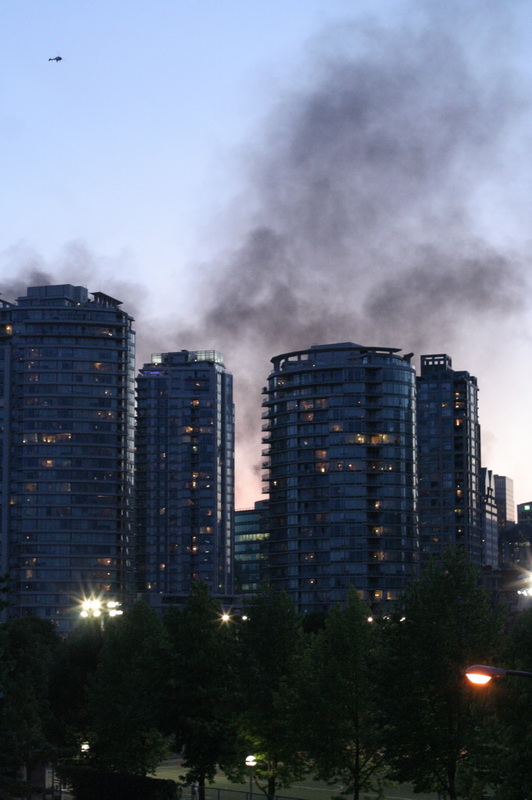


6.6 Mw - NEW BRITAIN REGION, P.N.G.
Preliminary Earthquake ReportMagnitude 6.6 Mw Date-Time
- 16 Jun 2011 00:03:36 UTC
- 16 Jun 2011 10:03:36 near epicenter
- 15 Jun 2011 17:03:36 standard time in your timezone
Location 5.994S 151.095E Depth 21 km Distances
- 175 km (109 miles) E (81 degrees) of Kandrian, New Britain, PNG
- 231 km (144 miles) SSW (211 degrees) of Rabaul, New Britain, PNG
- 383 km (238 miles) S (175 degrees) of Kavieng, New Ireland, PNG
- 460 km (286 miles) E (80 degrees) of Lae, New Guinea, PNG
- 577 km (359 miles) NE (48 degrees) of PORT MORESBY, Papua New Guinea
Location Uncertainty Horizontal: 15.0 km; Vertical 7.3 km Parameters Nph = 180; Dmin = 231.5 km; Rmss = 1.06 seconds; Gp = 32°
M-type = Mw; Version = 8 Event ID US c00048pr
THIS IS THE LATEST POST AND DISCLOSURE PROJECT CONCERNING E.T.
Data Acquisition and ProcessingGOES SatelliteGOES satellite in space
A Local Readout Ground Station (LRGS) located at the U.S. Geological Survey in Menlo Park, California is used to access geophysical data sent through the NOAA Geostationary Operational Environmental Satellite (GOES). The GOES satellite, orbiting the earth at approximately 23,000 miles, supports a radio relay system for low frequency data collection systems. The National Environmental Satellite, Data, and Information Service (NESDIS) operates the data collection portion of the GOES system.
Instrument sites located in fault zones and volcanic regions transmit data to GOES. Data transmitted from the remote sites are received from GOES by the NOAA Command and Data Acquisition Station (CDA) in Wallops, Virginia, by the GOES Data Collection System (DCS) and are retransmitted to a domestic communications satellite(DOMSAT). The data stream from the DOMSAT is received by the LRGS in Menlo Park and processed within seconds of being tranmitted from the remote instrument location. Updates of data plots from the instruments are posted on the World Wide Web.
Data are transmitted from an instrument site every 10 minutes using either 12, 16, 18 or 22-bit digital telemetry. Removal of re-zeros, offsets, problems with telemetry and identification of instrument failures can be a difficult, tedious and timeconsuming task. In order to have a relatively up-to-date data file, computer algorithms have been written that attempt a first-pass at accomplishing these tasks automatically. Accurate and detailed analysis requires manual checking of the data.
Plotting the DataGOES view of Earth
Data for the various low frequency instruments are automatically processed on a regularly scheduled basis — typically every 30 minutes. Plots of the data for display on the Web are constructed from the auto-processed data files. The 7-day and 30-day plots available on this web site provide a preliminary look at data from various instruments. For purposes of detailed analysis, the data must be reviewed by associated researchers.
The plots are created using The Generic Mapping Tools (GMT) program. Plots of similar sensors in a region are available for display on the screen for either a 7-day or 30-day time period. Clicking on an instrument site on one of the instrument location maps will display plots for data from the site.
The plots on this site should not be used for engineering, legal, or any other critical applications.
Timing the DataEvery 10-minute data transmission is time tagged at time of receipt from the GOES satellite by a ground station in Wallops Island, Virginia. Although the time tag is within 2 seconds of the instrument transmit time, it does not indicate when the data samples were actually taken.
The timing of data sampling in the field is based on manually setting time in a data collection platform (DCP) at the field site. The clock internal to the DCP schedules subsequent data sampling through programming of the DCP. Because instrument sites may not be revisited for periods up to 6 months (or longer), drift of the DCP clock may cause timing of data sampling to vary from initial settings.
All low frequency data are stored, plotted, and distributed in Coordinated Universal Time (UTC) (formerly known as GMT, or Greenwich Mean Time). To provide a measure of consistancy in the data archive system, data received during a given 10-minute time period are time tagged with the preceeding, even 10-minute mark. Thus data received at 1056 UTC are tagged as 1050 UTC.
In most cases, due to the sampling frequency and the nature of the data, precise timing information is not required. If, however, timing issues are pertinent to a study, the responsible researcher should be contacted concerning more precise data sample timing.
The timing information on data plots and in data distributed from this site are not meant to reflect the most accurate timing information available. In general, time information should be taken as an approximation (within 10 minutes) of the time of actual data samples.
This map shows the liquefaction hazard in the communities of Alameda, Berkeley, Emeryville, Oakland, and Piedmont for a magnitude 7.1 earthquake on the Hayward fault. The map predicts the approximate percentage of each designated area that will liquefy and show surface manifestations of liquefaction such as sand boils and ground cracking. Liquefaction is a phenomenon that is caused by earthquake shaking. Wet sand can become liquid-like when strongly shaken. The liquefied sand may flow and the ground may crack and move causing damage to surface structures and underground utilities. The map depicts the hazard at a regional scale and should not be used for site-specific design and consideration. Subsurface conditions can vary abruptly and borings are required to address the hazard at a given location. http://earthquake.usgs.gov/regional/nca/alameda/
Many regions of man-made landfill liquefied in the 1989 Loma Prieta earthquake. The Marina district, a shallow bay filled in after the 1906 earthquake, suffered some of the worst damage in the 1989 earthquake (USGS photo).
These new maps cover the San Francisco Bay region (outlined in red). A previous USGS map, published in 2000, covers a larger region (outlined in black).
Northern San Francisco and the Marin peninsula are not included in the new maps because geologic field mapping in these regions is incomplete. Please use the older map for areas not covered by the new map. The older map also shows locations of liquefaction observed in historical earthquakes, particularly the Great 1906 earthquake and the 1989 Loma Prieta quake.
In addition, the California Geological Survey has zoned the greater San Francisco area for liquefaction hazard in theirseismic hazard maps.
We can expect history to repeat itself in the next big Bay Area earthquake.
The highest hazard areas shown by the liquefaction hazard maps are concentrated in regions of man-made landfill, especially fill that was placed many decades ago in areas that were once submerged bay floor. Such areas along the Bay margins are found in San Francisco, Oakland and Alameda Island, as well as other places around San Francisco Bay. Other potentially hazardous areas include those along some of the larger streams, which produce the loose young soils that are particularly susceptible to liquefaction.
These new maps show a lower likelihood of liquefaction than previously thought in regions underlain by Bay mud that fringes many parts of San Francisco Bay. Bay mud remains a seismic hazard because on the basis of its past performance in earthquakes it will produce stronger levels of shaking than other geologic units.
The new maps show in unprecedented detail the nature of the materials that underlie areas of densest urban development and highlight areas that may be prone to shaking-related damage during future earthquakes.
These maps are the result of over a decade of work and collaboration between geologists from the consulting firm William Lettis & Associates, the U.S. Geological Survey, and the California Geological Survey.
Many of the region’s utilities and lifeline owners have made use of anearlier version of these maps in vulnerability assessments of their systems.
More Information- USGS Open File Report
Maps of Quaternary Deposits and Liquefaction Susceptibility in the Central San Francisco Bay Region, California - 1906 Centennial Alliance web site
complete list of 1906 Centennial events, exhibits, lectures, and publications - Liquefaction-related regulatory maps
Produced by the California Geological Survey
Maps of Quaternary Deposits and Liquefaction Susceptibility in the Central San Francisco Bay Region, California
complete list of 1906 Centennial events, exhibits, lectures, and publications
Produced by the California Geological Survey
ABOVE IS SOME BASIC FORECASTING DATA, A 31 SECOND VIDEO ON TSUNAMI PROOF HOUSES, AND PROJECTION MODELS FOR THE WESTERN UNITED STATES AS WELL AS SITE ADDRESSES FOR MORE INFO... BELOW IS REAL TIME GLOBAL SEISMIC DATA TAKEN AT THE TIME STATED UNDERNEATH THIS DISCLAIMER...I WILL CONTINUE TO KEEP YOU POSTED AS NEW DATA COMES IN...TAKE CARE OF EACH OTHER OUT THERE!
ALEXANDER PMG.. PRESIDENT-COPD--community organization
Update time = Mon Jun 13 17:00:03 UTC 2011
MAG
UTC DATE-TIME
y/m/d h:m:s
LAT
deg
LON
deg
DEPTH
km RegionMAP 6.2 2011/06/13 14:31:17 2.516 126.438 13.7 MOLUCCA SEA MAP 4.7 2011/06/13 14:01:27 37.471 144.081 10.0 OFF THE EAST COAST OF HONSHU, JAPAN MAP 4.6 2011/06/13 13:09:21 38.629 143.250 10.0 OFF THE EAST COAST OF HONSHU, JAPANMAP 5.4 2011/06/13 12:46:00 -19.186 -177.490 563.5 FIJI REGION MAP 2.6 2011/06/13 12:10:15 17.805 -68.667 13.8 DOMINICAN REPUBLIC REGION MAP 4.6 2011/06/13 12:04:05 -9.177 122.987 86.7 SAVU SEA MAP 2.5 2011/06/13 11:34:12 60.054 -140.914 13.8 SOUTHERN YUKON TERRITORY, CANADA MAP 2.9 2011/06/13 11:15:07 18.086 -65.526 86.0 ISLA DE VIEQUES, PUERTO RICO MAP 2.9 2011/06/13 10:56:58 36.157 -120.194 9.5 CENTRAL CALIFORNIA MAP 3.0 2011/06/13 09:25:10 59.358 -150.693 40.0 KENAI PENINSULA, ALASKA MAP 4.7 2011/06/13 08:40:19 -0.257 119.926 7.9 MINAHASA, SULAWESI, INDONESIA MAP 2.9 2011/06/13 07:49:10 19.090 -67.247 26.5 PUERTO RICO REGION MAP 5.0 2011/06/13 06:50:33 39.981 143.034 24.2 OFF THE EAST COAST OF HONSHU, JAPAN MAP 4.8 2011/06/13 06:38:42 -15.842 -173.170 25.5 TONGA MAP 4.2 2011/06/13 05:50:53 43.251 139.141 211.6 EASTERN SEA OF JAPAN MAP 2.6 2011/06/13 05:49:24 32.365 -115.549 3.4 BAJA CALIFORNIA, MEXICO MAP 4.7 2011/06/13 05:19:56 -32.390 -71.088 49.1 VALPARAISO, CHILE MAP 3.2 2011/06/13 05:18:35 18.124 -64.437 113.2 VIRGIN ISLANDS REGION MAP 2.6 2011/06/13 03:03:13 17.893 -68.587 35.3 DOMINICAN REPUBLIC REGION MAP 4.6 2011/06/13 02:40:31 -43.560 172.805 12.5 SOUTH ISLAND OF NEW ZEALAND MAP 6.0 2011/06/13 02:20:51 -43.580 172.740 9.0 SOUTH ISLAND OF NEW ZEALAND MAP 5.2 2011/06/13 01:00:00 -43.580 172.780 11.0 SOUTH ISLAND OF NEW ZEALAND MAP 4.7 2011/06/13 00:25:30 39.930 143.422 29.4 OFF THE EAST COAST OF HONSHU, JAPAN MAP 4.9 2011/06/13 00:02:37 -60.475 -56.469 14.3 SOUTH SHETLAND ISLANDS MAG
UTC DATE-TIME
y/m/d h:m:s
LAT
deg
LON
deg
DEPTH
km RegionMAP 2.8 2011/06/12 23:49:19 41.045 -125.242 2.6 OFFSHORE NORTHERN CALIFORNIA MAP 4.7 2011/06/12 23:24:47 -21.305 -70.513 41.9 OFFSHORE ANTOFAGASTA, CHILE MAP 4.6 2011/06/12 21:41:57 13.309 41.668 15.3 ERITREA - ETHIOPIA REGION MAP 4.5 2011/06/12 21:37:14 13.234 41.806 15.0 ERITREA - ETHIOPIA REGION MAP 5.7 2011/06/12 21:03:23 13.530 41.625 9.9 ERITREA - ETHIOPIA REGION MAP 5.0 2011/06/12 20:48:16 28.099 129.955 19.7 RYUKYU ISLANDS, JAPAN MAP 5.7 2011/06/12 20:32:41 13.460 41.688 10.1 ERITREA - ETHIOPIA REGIONMAP 4.7 2011/06/12 20:32:27 -8.470 -74.781 144.3 CENTRAL PERU MAP 4.9 2011/06/12 19:52:31 -4.699 143.716 104.0 NEW GUINEA, PAPUA NEW GUINEA MAP 4.8 2011/06/12 19:44:16 13.369 41.644 9.9 ERITREA - ETHIOPIA REGION MAP 4.7 2011/06/12 19:37:43 13.316 41.611 10.1 ERITREA - ETHIOPIA REGION MAP 5.0 2011/06/12 19:21:45 12.476 41.748 10.0 ETHIOPIA MAP 3.0 2011/06/12 18:23:24 59.679 -153.119 15.5 SOUTHERN ALASKA MAP 4.5 2011/06/12 18:01:19 12.817 41.933 10.1 ETHIOPIA MAP 4.7 2011/06/12 17:47:21 13.538 41.588 10.0 ERITREA - ETHIOPIA REGION MAP 4.8 2011/06/12 17:18:10 13.381 41.764 9.9 ERITREA - ETHIOPIA REGION MAP 2.7 2011/06/12 16:51:48 32.236 -97.002 5.0 NORTHERN TEXAS MAP 4.3 2011/06/12 16:33:12 13.507 41.722 10.0 ERITREA - ETHIOPIA REGION MAP 4.8 2011/06/12 16:24:44 13.436 41.682 10.0 ERITREA - ETHIOPIA REGION MAP 2.5 2011/06/12 16:15:47 36.389 -117.881 5.6 CENTRAL CALIFORNIA MAP 4.7 2011/06/12 16:12:03 13.397 41.734 10.0 ERITREA - ETHIOPIA REGION MAP 4.5 2011/06/12 16:09:30 13.443 41.696 2.9 ERITREA - ETHIOPIA REGIONMAP 5.1 2011/06/12 15:37:05 13.458 41.684 10.0 ERITREA - ETHIOPIA REGION MAP 4.4 2011/06/12 14:51:57 17.029 121.760 28.8 LUZON, PHILIPPINES MAP 4.7 2011/06/12 14:30:50 -4.346 122.805 31.9 SULAWESI, INDONESIA MAP 3.0 2011/06/12 14:21:41 59.674 -153.409 119.0 SOUTHERN ALASKA MAP 2.8 2011/06/12 13:21:21 51.466 -177.145 55.5 ANDREANOF ISLANDS, ALEUTIAN IS., ALASKA MAP 5.0 2011/06/12 12:57:57 36.195 141.630 33.3 NEAR THE EAST COAST OF HONSHU, JAPAN MAP 2.6 2011/06/12 12:51:00 51.457 -175.790 26.7 ANDREANOF ISLANDS, ALEUTIAN IS., ALASKA MAP 5.0 2011/06/12 11:56:03 -56.178 -27.373 96.8 SOUTH SANDWICH ISLANDS REGION MAP 4.7 2011/06/12 11:17:48 17.328 -94.956 126.3 VERACRUZ, MEXICO MAP 5.2 2011/06/12 11:16:39 56.224 164.203 31.8 KOMANDORSKIYE OSTROVA, RUSSIA REGION MAP 4.8 2011/06/12 10:17:57 12.838 -88.483 84.3 OFFSHORE EL SALVADOR MAP 2.6 2011/06/12 09:08:01 60.091 -152.774 98.4 SOUTHERN ALASKA MAP 2.8 2011/06/12 08:36:28 38.811 -69.210 5.0 OFF THE EAST COAST OF THE UNITED STATES MAP 4.9 2011/06/12 08:09:47 36.404 141.005 45.4 NEAR THE EAST COAST OF HONSHU, JAPAN MAP 4.9 2011/06/12 06:34:41 -6.106 148.903 79.0 NEW BRITAIN REGION, PAPUA NEW GUINEA MAP 4.6 2011/06/12 06:24:13 3.958 126.213 62.7 KEPULAUAN TALAUD, INDONESIA MAP 3.0 2011/06/12 06:12:19 19.150 -67.444 12.0 PUERTO RICO REGION MAP 5.3 2011/06/12 05:24:27 -14.365 171.352 626.9 VANUATU REGION MAP 2.9 2011/06/12 04:55:04 52.648 -169.296 12.2 FOX ISLANDS, ALEUTIAN ISLANDS, ALASKA MAP 4.8 2011/06/12 03:30:53 -25.631 -176.678 35.3 SOUTH OF THE FIJI ISLANDS MAP 2.7 2011/06/12 02:56:17 38.778 -122.748 0.0 NORTHERN CALIFORNIA MAP 3.0 2011/06/12 02:54:13 38.776 -122.750 0.0 NORTHERN CALIFORNIA MAP 2.5 2011/06/12 02:04:55 36.525 -120.667 14.6 CENTRAL CALIFORNIA MAP 2.8 2011/06/12 00:41:37 19.108 -67.813 53.7 DOMINICAN REPUBLIC REGION MAP 4.7 2011/06/12 00:38:02 35.796 140.602 34.5 NEAR THE EAST COAST OF HONSHU, JAPANMAP 3.2 2011/06/12 00:35:40 19.050 -67.575 7.0 PUERTO RICO REGION MAG
UTC DATE-TIME
y/m/d h:m:s
LAT
deg
LON
deg
DEPTH
km RegionMAP 4.7 2011/06/11 22:23:36 12.722 -88.370 101.0 OFFSHORE EL SALVADORMAP 3.3 2011/06/11 21:08:46 38.358 -122.570 10.4 NORTHERN CALIFORNIA MAP 4.6 2011/06/11 20:23:08 -6.644 106.410 9.2 JAVA, INDONESIA MAP 2.7 2011/06/11 20:20:54 62.103 -149.402 16.4 CENTRAL ALASKA MAP 4.6 2011/06/11 20:08:57 37.032 141.371 10.1 NEAR THE EAST COAST OF HONSHU, JAPAN MAP 4.7 2011/06/11 19:17:49 -6.768 129.360 16.3 BANDA SEA MAP 4.4 2011/06/11 19:00:03 -6.777 129.315 38.9 BANDA SEA MAP 4.3 2011/06/11 18:51:57 15.494 -104.818 14.0 OFF THE COAST OF MICHOACAN, MEXICO MAP 3.3 2011/06/11 17:19:46 32.236 -115.099 44.6 BAJA CALIFORNIA, MEXICO MAP 4.8 2011/06/11 16:31:20 39.724 143.145 32.7 OFF THE EAST COAST OF HONSHU, JAPANMAP 4.7 2011/06/11 16:26:36 50.435 159.344 43.7 EAST OF THE KURIL ISLANDS MAP 2.9 2011/06/11 15:44:18 18.372 -67.926 102.0 DOMINICAN REPUBLIC REGION MAP 4.7 2011/06/11 14:02:43 38.021 144.672 38.0 OFF THE EAST COAST OF HONSHU, JAPAN MAP 2.6 2011/06/11 13:32:27 61.076 -145.671 10.3 SOUTHERN ALASKA MAP 3.4 2011/06/11 13:19:36 55.608 -158.298 20.7 ALASKA PENINSULA MAP 3.2 2011/06/11 12:31:51 61.033 -146.311 12.0 SOUTHERN ALASKA MAP 5.3 2011/06/11 11:21:52 -58.209 -14.034 10.0 EAST OF THE SOUTH SANDWICH ISLANDS MAP 2.9 2011/06/11 11:16:01 19.404 -155.492 9.7 ISLAND OF HAWAII, HAWAII MAP 3.1 2011/06/11 11:04:11 18.926 -65.027 75.3 VIRGIN ISLANDS REGION MAP 2.7 2011/06/11 09:58:00 18.522 -67.655 17.8 MONA PASSAGE, PUERTO RICO MAP 4.6 2011/06/11 09:05:01 37.582 142.703 20.7 OFF THE EAST COAST OF HONSHU, JAPAN MAP 3.6 2011/06/11 08:17:48 33.639 -119.059 3.0 CHANNEL ISLANDS REGION, CALIFORNIA MAP 2.9 2011/06/11 07:36:36 60.062 -140.907 13.4 SOUTHERN YUKON TERRITORY, CANADA MAP 3.3 2011/06/11 06:58:13 59.992 -140.867 0.0 SOUTHEASTERN ALASKA MAP 4.7 2011/06/11 04:17:01 35.384 141.111 18.6 NEAR THE EAST COAST OF HONSHU, JAPAN MAP 2.5 2011/06/11 02:10:30 59.992 -152.115 45.6 SOUTHERN ALASKA MAG
UTC DATE-TIME
y/m/d h:m:s
LAT
deg
LON
deg
DEPTH
km RegionMAP 3.3 2011/06/10 23:27:32 32.633 -115.757 1.0 BAJA CALIFORNIA, MEXICO MAP 5.1 2011/06/10 22:35:57 38.310 142.222 44.8 NEAR THE EAST COAST OF HONSHU, JAPAN MAP 4.5 2011/06/10 19:41:19 16.169 -98.366 16.5 OFFSHORE OAXACA, MEXICOMAP 4.6 2011/06/10 19:07:10 -5.566 151.793 50.3 NEW BRITAIN REGION, PAPUA NEW GUINEA MAP 4.8 2011/06/10 18:33:25 36.773 142.100 36.3 OFF THE EAST COAST OF HONSHU, JAPAN MAP 3.1 2011/06/10 18:15:58 51.246 -165.246 40.4 SOUTH OF THE ALEUTIAN ISLANDS MAP 3.3 2011/06/10 17:28:03 32.173 -115.308 32.9 BAJA CALIFORNIA, MEXICO MAP 5.3 2011/06/10 15:32:49 -6.680 -122.720 10.1 SOUTH PACIFIC OCEAN MAP 3.3 2011/06/10 15:15:21 61.070 -145.719 17.4 SOUTHERN ALASKA MAP 4.9 2011/06/10 14:45:27 -23.947 -69.393 79.5 ANTOFAGASTA, CHILE MAP 2.8 2011/06/10 14:34:16 32.369 -115.523 22.2 BAJA CALIFORNIA, MEXICO MAP 4.9 2011/06/10 14:31:03 -14.905 171.059 655.1 VANUATU REGION MAP 2.9 2011/06/10 14:03:42 18.625 -68.404 13.9 DOMINICAN REPUBLIC MAP 3.0 2011/06/10 13:58:38 18.975 -68.284 87.0 DOMINICAN REPUBLIC REGION MAP 4.8 2011/06/10 13:42:28 -7.376 156.187 58.1 SOLOMON ISLANDSMAP 2.6 2011/06/10 13:41:09 18.738 -68.355 24.8 DOMINICAN REPUBLIC REGION MAP 4.8 2011/06/10 13:39:45 38.691 141.755 47.3 NEAR THE EAST COAST OF HONSHU, JAPANMAP 4.7 2011/06/10 13:13:27 16.429 -98.322 13.9 GUERRERO, MEXICO MAP 3.1 2011/06/10 12:51:13 32.617 -115.737 4.2 BAJA CALIFORNIA, MEXICO MAP 4.6 2011/06/10 09:53:26 -4.951 134.037 33.8 NEAR THE SOUTH COAST OF PAPUA, INDONESIA MAP 4.8 2011/06/10 08:28:14 -7.080 39.628 10.0 TANZANIA MAP 4.6 2011/06/10 08:18:37 36.387 140.631 50.4 NEAR THE EAST COAST OF HONSHU, JAPAN MAP 2.8 2011/06/10 06:31:10 53.431 -165.388 32.0 FOX ISLANDS, ALEUTIAN ISLANDS, ALASKA MAP 4.8 2011/06/10 04:55:41 -26.249 -70.619 24.3 ATACAMA, CHILE MAP 3.8 2011/06/10 04:44:40 13.899 -91.361 67.5 OFFSHORE GUATEMALA MAP 4.9 2011/06/10 01:25:22 23.576 121.562 31.3 TAIWAN MAP 4.6 2011/06/10 01:13:33 14.509 146.730 50.7 ROTA REGION, NORTHERN MARIANA ISLANDS MAP 5.2 2011/06/10 00:58:58 -6.700 150.490 24.9 NEW BRITAIN REGION, PAPUA NEW GUINEA MAP 2.7 2011/06/10 00:38:53 60.111 -152.760 94.7 SOUTHERN ALASKA MAP 2.7 2011/06/10 00:25:38 18.696 -67.485 16.2 PUERTO RICO REGION MAP 5.2 2011/06/10 00:11:22 -6.665 147.907 38.6 EASTERN NEW GUINEA REG, PAPUA NEW GUINEA MAG
UTC DATE-TIME
y/m/d h:m:s
LAT
deg
LON
deg
DEPTH
km RegionMAP 4.8 2011/06/09 23:04:01 -39.342 -72.254 35.7 ARAUCANIA, CHILE MAP 5.4 2011/06/09 20:16:31 -30.361 -177.924 46.5 KERMADEC ISLANDS, NEW ZEALAND MAP 2.6 2011/06/09 17:42:43 32.641 -115.743 3.2 BAJA CALIFORNIA, MEXICO MAP 2.9 2011/06/09 17:41:23 32.637 -115.745 3.1 BAJA CALIFORNIA, MEXICO MAP 4.1 2011/06/09 16:16:33 40.716 19.864 7.0 ALBANIA MAP 4.7 2011/06/09 15:40:57 37.909 141.531 53.7 NEAR THE EAST COAST OF HONSHU, JAPAN MAP 4.4 2011/06/09 15:22:12 32.663 -115.737 15.1 SOUTHERN CALIFORNIA MAP 2.8 2011/06/09 14:56:37 35.669 -121.107 6.6 CENTRAL CALIFORNIA MAP 3.1 2011/06/09 14:01:14 52.060 179.940 49.5 RAT ISLANDS, ALEUTIAN ISLANDS, ALASKA MAP 3.0 2011/06/09 13:18:50 38.832 -118.705 10.6 NEVADA MAP 4.8 2011/06/09 12:09:49 -3.541 150.562 39.2 NEW IRELAND REGION, PAPUA NEW GUINEAMAP 5.4 2011/06/09 10:38:34 36.408 140.842 11.3 NEAR THE EAST COAST OF HONSHU, JAPAN MAP 5.1 2011/06/09 10:26:06 37.266 142.143 20.8 OFF THE EAST COAST OF HONSHU, JAPAN MAP 4.8 2011/06/09 10:13:16 32.203 49.975 36.4 WESTERN IRAN MAP 5.0 2011/06/09 09:51:04 14.148 92.893 38.6 ANDAMAN ISLANDS, INDIA REGION MAP 3.9 2011/06/09 07:40:31 59.577 -152.483 82.4 SOUTHERN ALASKA MAP 4.4 2011/06/09 07:34:26 23.585 89.738 14.4 BANGLADESH MAP 4.8 2011/06/09 07:12:06 44.140 147.706 103.1 KURIL ISLANDS MAP 2.6 2011/06/09 06:25:22 32.795 -116.154 6.6 SOUTHERN CALIFORNIA MAP 2.6 2011/06/09 05:35:04 19.068 -156.297 38.6 HAWAII REGION, HAWAII MAP 4.7 2011/06/09 03:28:35 -55.574 -29.099 28.0 SOUTH SANDWICH ISLANDS REGION MAP 4.9 2011/06/09 03:21:06 -20.282 168.299 11.9 LOYALTY ISLANDSMAP 4.7 2011/06/09 00:12:08 25.060 125.906 40.5 SOUTHWESTERN RYUKYU ISLANDS, JAPAN MAG
UTC DATE-TIME
y/m/d h:m:s
LAT
deg
LON
deg
DEPTH
km RegionMAP 5.0 2011/06/08 22:27:48 -20.266 168.212 59.0 LOYALTY ISLANDS MAP 5.0 2011/06/08 22:11:17 39.064 142.351 39.6 NEAR THE EAST COAST OF HONSHU, JAPANMAP 5.3 2011/06/08 21:46:04 -20.334 168.347 47.4 LOYALTY ISLANDS MAP 4.8 2011/06/08 21:07:27 -23.053 -174.527 27.4 TONGA REGION MAP 3.2 2011/06/08 21:01:41 19.203 -68.473 81.7 DOMINICAN REPUBLIC REGION MAP 3.6 2011/06/08 20:57:56 19.348 -68.420 52.6 DOMINICAN REPUBLIC REGION MAP 2.7 2011/06/08 20:53:11 19.193 -68.257 92.1 DOMINICAN REPUBLIC REGION MAP 2.8 2011/06/08 20:13:34 38.834 -122.803 2.6 NORTHERN CALIFORNIA MAP 2.7 2011/06/08 19:04:33 63.213 -149.223 82.9 CENTRAL ALASKA MAP 2.9 2011/06/08 18:13:47 31.203 -115.699 10.0 BAJA CALIFORNIA, MEXICO MAP 2.8 2011/06/08 16:56:14 32.059 -115.037 10.0 BAJA CALIFORNIA, MEXICO MAP 5.3 2011/06/08 16:32:18 1.172 96.778 21.0 NIAS REGION, INDONESIA MAP 5.3 2011/06/08 15:40:15 -4.566 149.939 509.7 BISMARCK SEA MAP 2.6 2011/06/08 15:18:07 41.130 -123.542 22.8 NORTHERN CALIFORNIA MAP 4.4 2011/06/08 10:53:04 -16.408 -69.811 199.0 SOUTHERN PERU MAP 2.7 2011/06/08 09:26:46 55.880 -153.982 41.0 SOUTH OF ALASKA MAP 2.5 2011/06/08 09:03:27 55.937 -156.075 43.9 SOUTH OF ALASKA MAP 4.7 2011/06/08 08:48:50 -5.185 102.438 45.1 SOUTHERN SUMATRA, INDONESIA MAP 4.7 2011/06/08 07:53:45 41.459 142.456 25.5 HOKKAIDO, JAPAN REGION MAP 2.5 2011/06/08 07:05:25 39.935 -111.825 3.9 UTAH MAP 4.6 2011/06/08 06:35:20 5.064 -82.534 26.0 SOUTH OF PANAMA MAP 3.5 2011/06/08 05:40:26 61.657 -147.646 25.7 SOUTHERN ALASKA MAP 5.0 2011/06/08 04:41:34 -33.975 -72.106 27.2 OFFSHORE LIBERTADOR O'HIGGINS, CHILE MAP 5.4 2011/06/08 04:27:47 -20.277 168.315 10.2 LOYALTY ISLANDS MAP 4.6 2011/06/08 03:55:53 -21.430 -68.071 100.9 POTOSI, BOLIVIA MAP 3.4 2011/06/08 03:45:21 54.674 -161.130 9.2 ALASKA PENINSULA MAP 6.0 2011/06/08 03:06:18 -17.059 -69.498 101.3 SOUTHERN PERU MAP 4.8 2011/06/08 03:05:04 43.059 88.648 26.6 NORTHERN XINJIANG, CHINA MAP 2.5 2011/06/08 02:15:21 66.029 -151.620 10.7 NORTHERN ALASKA MAP 5.3 2011/06/08 01:53:27 43.034 88.260 26.9 NORTHERN XINJIANG, CHINA MAG
UTC DATE-TIME
y/m/d h:m:s
LAT
deg
LON
deg
DEPTH
km RegionMAP 3.1 2011/06/07 23:28:53 58.082 -155.669 109.0 ALASKA PENINSULA MAP 3.4 2011/06/07 22:49:38 19.306 -155.000 38.5 HAWAII REGION, HAWAII MAP 2.6 2011/06/07 20:51:53 34.230 -117.055 2.5 SOUTHERN CALIFORNIA MAP 4.3 2011/06/07 20:51:35 11.256 -86.666 79.3 NEAR THE COAST OF NICARAGUA MAP 2.9 2011/06/07 16:30:10 34.097 -117.270 13.1 GREATER LOS ANGELES AREA, CALIFORNIA MAP 5.4 2011/06/07 14:55:20 15.355 -93.072 75.8 CHIAPAS, MEXICO MAP 2.7 2011/06/07 12:30:15 51.443 -177.782 53.5 ANDREANOF ISLANDS, ALEUTIAN IS., ALASKA MAP 4.6 2011/06/07 10:53:50 1.310 97.045 33.8 NIAS REGION, INDONESIA MAP 5.3 2011/06/07 10:38:31 48.320 154.240 58.1 KURIL ISLANDS MAP 3.6 2011/06/07 10:08:24 19.035 -64.288 64.1 VIRGIN ISLANDS REGION MAP 4.9 2011/06/07 09:32:25 -28.169 -112.928 10.1 EASTER ISLAND REGION MAP 4.7 2011/06/07 09:08:35 32.761 71.809 39.8 PAKISTAN MAP 3.0 2011/06/07 08:54:40 18.952 -64.430 29.7 VIRGIN ISLANDS REGION MAP 4.8 2011/06/07 08:52:11 -17.846 -178.456 516.2 FIJI REGION MAP 4.5 2011/06/07 08:34:01 10.422 126.212 75.9 PHILIPPINE ISLANDS REGION MAP 3.9 2011/06/07 08:10:37 38.077 -90.902 20.9 MISSOURI MAP 3.0 2011/06/07 06:46:25 18.199 -67.742 71.3 MONA PASSAGE, PUERTO RICO MAP 3.0 2011/06/07 05:45:18 58.386 -133.513 5.3 SOUTHEASTERN ALASKA MAP 5.3 2011/06/07 05:18:33 -44.181 -16.120 10.3 SOUTHERN MID-ATLANTIC RIDGEMAP 5.0 2011/06/07 05:11:14 -44.052 -15.931 10.1 SOUTHERN MID-ATLANTIC RIDGEMAP 4.7 2011/06/07 03:52:31 40.310 143.328 25.6 OFF THE EAST COAST OF HONSHU, JAPAN MAP 4.6 2011/06/07 03:27:41 1.205 96.937 60.4 NIAS REGION, INDONESIA MAP 5.0 2011/06/07 02:54:24 1.197 96.766 42.6 NIAS REGION, INDONESIA MAP 4.5 2011/06/07 01:07:08 -34.495 -72.146 25.7 OFFSHORE LIBERTADOR O'HIGGINS, CHILE MAP 4.8 2011/06/07 01:06:42 36.970 142.044 44.0 OFF THE EAST COAST OF HONSHU, JAPANMAP 5.0 2011/06/07 00:39:30 -3.748 145.778 35.6 NEAR NORTH COAST OF NEW GUINEA, P.N.G. MAG
UTC DATE-TIME
y/m/d h:m:s
LAT
deg
LON
deg
DEPTH
km RegionMAP 4.6 2011/06/06 23:07:11 5.584 126.481 92.2 MINDANAO, PHILIPPINESMAP 4.9 2011/06/06 20:10:27 37.755 141.494 45.9 NEAR THE EAST COAST OF HONSHU, JAPAN MAP 3.3 2011/06/06 19:56:22 50.662 -170.404 20.0 SOUTH OF THE ALEUTIAN ISLANDS MAP 2.9 2011/06/06 19:40:12 18.734 -64.396 56.5 ANEGADA, BRITISH VIRGIN ISLANDS MAP 3.5 2011/06/06 19:37:43 51.807 -176.847 68.8 ANDREANOF ISLANDS, ALEUTIAN IS., ALASKA MAP 4.9 2011/06/06 18:52:26 37.560 143.659 51.3 OFF THE EAST COAST OF HONSHU, JAPAN
Most recent earthquakes are at the top of this list.
PART I - GEOGRAPHIC RELATIONSHIPS
The Great Pyramid is aligned with Machu Picchu, the Nazca lines and Easter Island along a straight line around the center of the Earth, within a margin of error of less than one tenth of one degree of latitude. Other sites of ancient construction that are also within one tenth of one degree of this line include: Perseopolis, the capital city of ancient Persia; Mohenjo Daro, the ancient capital city of the Indus Valley; and the lost city of Petra. The Ancient Sumarian city of Ur and the temples at Angkor Wat are within one degree of latitude of this line.
The alignment of these sites is easily observable on a globe of the Earth with a horizon ring. If you line up any two of these sites on the horizon ring, all of the sites will be right on the horizon ring. 3-D world atlas software programs can also draw this line around the Earth.
Start on the Equator, at the mouth of the Amazon River, at 49° 17' West Longitude; go to 30° 18' North Latitude, 40° 43' East Longitude, in the Middle East, which is the maximum latitude the line touches; then go to the Equator at 130° 43' East Longitude, near the Northwest tip of New Guinea; then to 30° 18' South Latitude, 139° 17' West Longitude, in the South Pacific; and then back to 49° 17' West Longitude, at the Equator.
Centered on
0.00° N, 49° 17' W
Centered on
30° 18' N, 40° 43' E
Centered on
0.00° N, 130° 43' E
Centered on
30° 18' S, 139° 17' W
The circumference of this line around the center of the Earth is 24,892 miles. Along this line, the great circle distance from,
· the Great Pyramid to Machupicchu is 7,487 miles, 30.0% of the circumference.
· Machupicchu is 2,564 miles from Easter Island, 10.3%.
· Easter Island is 10,096 miles from Angkor Wat, 40.6%.
· Angkor Wat is 2,490 miles from Mohenjo Daro, 10.0%.
· Mohenjo Daro is 2255 miles from from the Great Pyramid, 9.1%.
In addition to calculating the distances between these sites as a percentage of the circumference of the Earth, the distances may also be calculated in degrees of the 360° circumference, by multiplying the percentage by 3.6. For example, the Great Pyramid is 108° away from Machupicchu.
Angkor Wat and Angkor Thom were constructed at a time when 72 temples were built across the Angkor Plain. The Angkor temple at Prassat Preah Vihear, 90 miles Northeast of Angkor Wat, is within one tenth of one degree of the line. Like Machupicchu, the temple at Prassat Preah Vihear was built on the edge of a mountaintop. The first temples built around Angkor are near the city of Rolous, Southeast of Angkor Wat. The temples near Rolous are also thought to have been built on foundations constructed at a much earlier time.
Halfway between Angkor Wat and the Great Pyramid is the Indus Valley, the city of Mohenjo Daro, and the unexcavated city of Ganweriwala, which is East of Mohenjo Daro, and thought to be just as large. Both of these sites are on the line between Angkor and the Great Pyramid. The Indus Valley is also antipodal to Easter Island.
It is an interesting coincidence concerning these two sites, opposite each other on Earth, that of the few ancient written languages of the world that remain undeciphered, two are Indus Valley Script and Rongorongo, the written language of ancient Easter Island. The world's first known written languages, Egyptian Hieroglyphics and Sumerian Cuneiform, were also developed along this line of ancient sites. The Jewish, Christian, Muslim, Hindu, Brahman and Buddhist religions, as well as ancient Egyptian and Peruvian religions, were also developed along this line.
Anatom Island is the southernmost Island in the new Republic of Vanuatu, formerly known as the New Hebrides. Anatom Island is exactly halfway between Easter Island and Angkor Wat 5,048 miles each way, or 20.3% of the circumference of the Earth. Stone ruins on Anatom Island once housed the largest missionary church in the southern hemisphere.
The line crosses over the source and the mouth of the Amazon, the mouth of the Nile, the mouth of the Tigris-Euphrates, the Indus River and the Bay of Bengal near the mouth of the Ganges.
The line also crosses over a number of areas of the world that are largely unexplored or unexcavated, including the Sahara Desert, the Brazilian Rainforest, the highlands of New Guinea, and underwater areas of the North Atlantic Ocean, the South Pacific Ocean and the South China Sea. For example, the midway point between the Great Pyramid and Machupicchu is in the North Atlantic Ocean, less than one degree south of the Cape Verde Islands. This is also the midway point between Easter Island and the Indus Valley.
Although the Cape Verde Islands were found to be uninhabited when they were rediscovered in 1460 A.D., maps and geographical descriptions for the past 2000 years have shown this location to be the home of ancient island civilizations, including maps showing this location to be the site of Atlantis. In Plato's account of Atlantis, there was a mountainous region north of the city.
Are the higher elevations of those mountains now the Cape Verde Islands?
PART 2 - GOLDEN SECTION SITES - ANGKOR, THE GREAT PYRAMID & NAZCA
Angkor Wat is 4,745 miles from the Great Pyramid and the Great Pyramid is 7,677 miles from Nazca. This is a precise expression of ?, the Golden Section: 4,745 x 1.618 = 7,677
Ninety miles northeast of Angkor Wat are the Angkor temples at Prassat Preah Vihear. Prassat Vihear is 4754 miles from the Great Pyramid.
The line of ancient sites crosses over the Great Pyramid and Angkor Vihear.
Twenty five miles northwest of the city of Nazca is a figure known as the Hummingbird.
The Hummingbird is 7,692 miles from the Great Pyramid.
The line of ancient sites also crosses over the Hummingbird.
The relationship between the distances from Angkor Vihear to the Great Pyramid and from the Great Pyramid to the Nazcan Hummingbird is also a precise expression of phi:
4,754 x 1.618 = 7,692
Because the distance from the Hummingbird to Angkor Vihear is one-half of the circumference of the earth, two Golden Section relationships between these sites are shown by the circumference of the earth along the line of ancient sites:
These Golden Section relationships may also be diagramed on a straight line
The line of ancient sites is a line, from the perspective of the illustration in Part One, and it is a circle, from the perspective of the illustration in Part Six. The line and the circle are found in the Greek letter phi and the number 10. Zero and one are also the first two numbers and the only two numbers in the binary code.
The phi relationships between these sites are reflected repeatedly in the first 500 Fibonacci numbers. The first three prime numbers, 2, 3 and 5, approximate the intervals along the circumference of 20%, 30% and 50%, between these three sites. This same percentage of the circumference relationship, accurate to three digits, is found in Fibonacci numbers 137-139:
Percentage of
circumference:
Distance
between sites:
First three digits of
Fibonacci numbers:
First five digits of
Fibonacci numbers:
Angkor to Giza:
19.1%
4,754 miles
#137: 191... (Prime)
#359: 47542... (Prime)
Giza to Nazca:
30.9%
7,692 miles
#138: 309...
#360: 76924...
Nazca to Angkor:
50.0%
12,446 miles
#139: 500...
#361: 12446...
The next prime Fibonacci number after #137 is #359.
The distances between these sites, in miles, is reflected
by Fibocacci numbers 359-361, accurately to five digits.
PART 3 - LINES THROUGH THE EARTH
The line of ancient sites may be viewed as a circle because all of the sites are on a straight line around the center of the Earth. The intervals between the sites are based on their great circle distances from each other.
The circle is oriented so that the two points where the circle crosses the equator are on the horizontal axis, and the two points where the circle reaches its greatest latitudes are on the vertical axis.
G = The Great Pyramid
C = Cape Verde Islands
M = Machupicchu
N = Nazca
E = Easter Island
V = Anatom Island
A = Angkor Wat
I = Indus Valley
D = Mohenjo Daro
P = Perseopolis
U = Ur
R = Petra
Straight lines may be drawn through the Earth, connecting Easter Island to Machupicchu, the Great Pyramid, Angkor Wat, and the Indus Valley (antipodal to Easter Island).
The straight line distance, through the Earth, from Angkor Wat to Easter Island (7,574 miles), plus the straight line distance from Easter Island to Macchupicchu (2,522 miles), equals the great circle distance from Angkor Wat to Easter Island (10,096 miles).
The straight line distance from the Great Pyramid to Easter Island (7,566 miles) is three times the straight line distance from Easter Island to Machupicchu (2,522 miles).
The straight line distance from Easter Island to its antipodal point in the Indus Valley (7,924 miles), which is also the diameter of the Earth, is 3.1416 times the straight line distance from Easter Island to Machupicchu (2,522 miles), a precise expression of phi.
Since the circumference of the Earth is also 3.1416 times the diameter of the Earth, the straight line distance from Easter Island to Machupicchu times pi² equals the circumference of the Earth.
The angle formed by the lines from Easter Island to Machupicchu, and to the Indus Valley, is 72°. The angle formed by the lines from Easter Island to Machupicchu, and to the Great Pyramid, is 54°.
Lines connecting Easter Island, the Great Pyramid, and the Angkor temples near Rolous, form an isosceles triangle with base angles of 72.9°. The base of this triangle (AG) is 4462 miles long.
The height of this triangle (HE) is 7220 miles long. The length of the base of the triangle times phi equals the height of the triangle: 4,462 miles x 1.618 = 7,220 miles
The length of the base of each face of the Great Pyramid is 755.6 feet.
The slant height of each face is 611 feet.
One half of the length of the base times phi equals the slant height of the Great Pyramid:
755.6 feet ÷ 2 = 377.8 feet
377.8 feet x 1.618 = 611 feet
The ratio of the base to the slant height of the Great Pyramid is exactly two times the ratio of the base to the height of the triangle formed by through the earth straight lines connecting the Great Pyramid, Angkor and Easter Island.
Lines connecting Easter Island with it's antipodal point in the Indus Valley, Nazca with it's antipodal point at Angkor, Easter Island with Nazca and Angkor with the Indus Valley, form two isosceles triangles with base angles of 72.9°.
With the same angular dimensions as the triangle formed by Easter Island, Angkor and the Great Pyramid, the length of the bases of these triangles times phi also equals the height of these triangles:
2,337 miles x 1.618 = 3,782 miles
The ratio of the base to the slant height of the Great Pyramid is also exactly two times the ratio of the base to the height of the triangles formed by through the earth straight lines connecting Easter Island, Nazca and the center of the Earth, and Angkor, the Indus Valley and the center of the Earth.
Because the distance between the Great Pyramid and Angkor is very nearly 20% of the circumference, they are very nearly 72° apart, along the circle. Because the distance from the Great Pyramid to Easter Island is very nearly 40% of the circumference, and the distance from Angkor to Easter Island is very nearly 40% of the circumference, the Great Pyramid and Angkor are both very nearly 144° away from Easter Island, along the circle.
The number 72, and to a lesser extent the numbers 54, 108, and 144, have been associated with the designs of these sites, particularly at the Great Pyramid and Angkor. The ratio of the height and the perimeter of the Great Pyramid, to the size of the Earth, is a multiple of 72. The number of temples built around Angkor is 72, and the number 54 is reflected in the numbers of statuary in the temples at Angkor. The use of these numbers is also prevalent in ancient writings and folklore surrounding these sites. The number 54 is itself a factor of 72, in that 72 plus ½ of 72, or 36, equals 108, which divided by two equals 54.
The number 72 is also associated with the astronomical phenomenon known as precession, because 72 years is the length of time it takes for the constellations to move one degree due to precession. This has been offered as an explanation for the use of these numbers, suggesting that the builders of these sites were aware of the precession of the equinoxes.
In the 2nd century B.C., the Greek mathematician, Archimedes, wrote an article entitled The Sand Reckoner, in which he cited earlier Greek mathematicians (like Archimedes, they had studied in Alexandria and Heliopolis) who had calculated that the Sun occupied 1/720 of the circle of the constellations. This may be an additional, or alternative, explanation for the prevalence of the number 72, and its multiples and factors, found in these sites.
In any event, the existence of these numbers in the geometric relationships between these sites is complementary to the use of these numbers in their internal designs.
PART 4 - THE GREAT PYRAMID AND THE 30th PARALLEL
This circle has a different orientation than the previous diagrams and is two inches in diameter.
The horizontal axis is the Equator, FC is the 30th parallel, D is 60° North latitude and E is the North Pole.
The 30th parallel is exactly one-third of the great circle distance from the Equator to the North Pole, and it is located at exactly one-half of the height of the Northern Hemisphere.
Like the Great Pyramid, the maximum latitude of the line of ancient sites is very close to the 30th parallel.
This diagram illustrates that the relationship of the 30th parallel to the circumference of the Earth is the geometric relationship known as the Vesica Pisces.
In relation to the lower circumference, DE is at 30° N latitude.
In relation to the upper circumference, DE is at 30° S latitude.
The ratio between the straight line distance of the 30th parallel and the radius of the Earth is 1.732 to one. 1.732 is the square root of three.
Paul Michell and Charles Henry have noted the relationship between the Great Pyramid and the Vesica Pisces.
The small circles in this diagram are one inch in diameter, and the large circles are three inches in diameter, forming a small Vesica Pisces circumscribed by a larger one.
The triangle in this diagram has the same angular dimensions as the Great Pyramid.
The circle in this diagram also represents the circumference of the Earth with the poles on the vertical axis.
The radius of the circle is 1.00 inch.
The exterior and interior equilateral triangles touch the circle only at the 30th parallels and the poles.
The height of each equilateral triangle is 87% of the length of each of it’s sides:
3.00 ÷ 3.46 = .87
1.50 ÷ 1.73 = .87
1.00 ÷ 1.15 = .87
The length of each of the sides of the interior triangles, including the straight line distance through the earth at the 30th parallel, is also 87% of the diameter of the Earth:
1.73 ÷ 2.00 = .87
The radius of the Earth is also 87% of the distance from the center of the Earth to the point of the exterior triangles’ intersections (AP, AQ, AR, etc.):
1.00 ÷ 1.15 = .87
The Greek foot is thought to have been developed before the size and shape of the Earth was known and independently from the foot, which is also thought to have been developed before the size and shape of the Earth was known. The foot is 87% of the length of the Greek foot.
The mile, which is thought to have been developed before the size and shape of the Earth was known, is 87% of the length of the nautical mile, which was developed specifically in relation to the size of the Earth. The nautical mile equals one minute of latitude, so 60 nautical miles equals one degree of latitude and 5,400 nautical miles equals the 90 degrees of latitude between the Equator and the poles. The distance from the Equator to the poles is 6,215 miles:
5,400 ÷ 6,215 = .87
One minute of latitude equals one nautical mile at any longitude. At the equator, one minute of longitude also equals one nautical mile, but at higher latitudes, the distances between each minute of longitude become shorter. Because the straight line distance through the Earth at the 30th parallel is 87% of the diameter of the Earth, the circumference around the Earth at the 30th parallel is 87% of the circumference of the Earth at the Equator, and each minute of longitude at the 30th parallel is 87% of the distance of each minute of longitude at the Equator. As a result, just as one nautical mile equals one minute of longitude at the Equator, one standard mile equals one minute of longitude at the 30th parallel.
The currently accepted value for the Equatorial diameter of the Earth is 7,926 miles, with an Equatorial radius of 3,963 miles. The ratio of the radius of the Earth to the straight line distance through the Earth at the 30th parallel is 1:1.732.
3,963 miles x 1.732 = 6,864 miles (the straight line distance through the Earth at the 30th parallel).
6,864 miles x pi = 21,564 miles (the circumference of the Earth at the 30th parallel).
21,564 miles ÷ 360 degrees = 59.9 miles (one degree of longitude at the 30th parallel).
59.9 miles ÷ 60 minutes = .998 miles (one minute of longitude at the 30th parallel).
As an alternative proof, the currently accepted value for the Equatorial circumference of the Earth is 24,902 miles, and the circumference of the 30th parallel is 87% of the circumference of the Earth.
24,902 miles x .87 = 21,664 miles (the circumference of the Earth at the 30th parallel).
21,664 miles ÷ 360 degrees = 60.1 miles (one degree of longitude at the 30th parallel).
60.1 miles ÷ 60 = 1.00 miles (one minute of longitude at the 30th parallel).
Conclusion: One minute of longitude equals one mile at (or, like the Great Pyramid, just below) the 30th parallel.
PART 5 - ALIGNMENTS OF THE NAZCA LINES & FIGURES
The glyphs and lines at Nazca are oriented along the line of ancient sites. This image of the glyphs at Nazca, with a compass bearing, is available on the internet, but it is usually oriented away from the cardinal points so that the figures are roughly horizontal and vertical.
Rotating this image so that the north-south axis is vertical, aligns the figures and geometric drawings to the line of ancient sites as it crosses Nazca.
Nazca is marked by the yellow cross on the illustration [above]. The vertical line in the center of the picture is 75° West Longitude. The horizontal line is 15° South Latitude.
The white dot in red circle touching the north side of the line on the upper right side of the illustration is Machupicchu.
This below illustration of the Nazca lines has also been rotated so that the north-south axis is vertical, and shows the primary orientation of the lines is from Southwest to Northeast, along the line of ancient sites.
PART 6 - THE AXIS POINTS
Just as every point along the equator is 6,215 miles from both the North and South Poles, every point along the line of ancient sites is 6,215 miles from two axis points on Earth. The axis point in the Northern Hemisphere is near the Southeastern coast of Alaska, at 59° 42' N 139° 17' W, 25 miles Northeast of Yakutat, Alaska
The North and South Poles have not always been in their present locations. Several theories have been offered to explain observed and suspected movements of the poles in relation to the surface of the Earth. Plate tectonics, the prevailing theory, suggests gradual movements of the surface of the Earth. This theory has been called into question by recent measurements of relative movements of the earth's surface, and by accumulating seismological data. Alternative theories include: Axial shifts; polar wander; and a catastrophic form of polar wander known as Earth crust displacement.
Charles Hapgood advocated the Earth crust displacement theory in a book entitled The Path of the Poles. Hapgood supported this theory with geomagnetic and carbon dated evidence. In a book entitled When the Sky Fell, Rose and Rand Flem-Ath also advocate the Earth crust displacement theory, with additional geological and archeological evidence. Both of these works conclude that the North Pole was located in the Yukon, at 63° N 135° W, approximately 80,000 to100,000 years ago.
This is about 250 miles Northeast of the axis point for the line of ancient sites at 59° 42' N 139° 17' W. It is interesting to note that some of the heaviest remaining glaciations in all of North America is on the Southeastern coast of Alaska, surrounding Yakutat.
If 59° 42' N 139° 17' W was the location of the North Pole, then the line of ancient sites would have been the equator at that time. The concentric circles in the diagram represent lines of latitude from 59° 42' N 139° 17' W. The circle closest to the center of the diagram is 75°N, followed by 60°N, 45°N, 30°N and 15°N. The line of ancient sites is just beyond the horizon.
Since many of the sites along the line are precisely oriented to the present North and South Poles, it is not suggested that they were constructed when the poles were in a prior location. However, if this line had previously been the equator, the placement of these sites on this line would be a remarkable coincidence.
In a book entitled Atlantis Blueprint, Rand Flem-Ath and Colin Wilson have listed some of these sites, and a number of other sites, in relation to their calculation of the North Pole in the Yukon, including sites that would have been on the equator during this prior polar alignment. A line around the center of the earth, with the Yukon Pole as it’s axis point, approaches and crosses over the line of ancient sites at antipodal points in Peru and Cambodia. Along the line of ancient sites, the sites in these two areas are close to being equally distant from the Yukon Pole and from the Yakutat axis point.
None of the theories offered to explain the motions of the surface of the Earth, relative to the poles, can pinpoint exact prior polar positions. The round number coordinates that are used by Hapgood and the Flem-Aths for the Yukon Pole indicate that they are approximations. If the line of ancient sites was originally selected because of its equatorial relationship with a prior polar alignment, the most accurate way to determine the location of the prior alignment is to simply calculate it from the location of the line of ancient sites.
PART 7 - THE GREAT PYRAMID, PERU & PYTHAGORAS
The Great Pyramid precisely expresses the 2pi relationship between the circumference and the radius of the Earth.
· The height of the Great Pyramid is 481.4 feet.
· The perimeter of the Great Pyramid (the length of all four sides at the base of the pyramid) is 3,023 feet.
· The height of the Great Pyramid times 2pi (6.28) is 3,023 feet.
The relationship of the distances between the Great Pyramid, Nazca, and the axis point of the line of ancient sites, precisely expresses this same 2pi relationship.
Inspired by Charles Hapgood's Earth crust displacement theory, Jim Bowles, a retired NASA engineer, wrote The Gods, Gemini, and the Great Pyramid. In his book, Bowles provides a scientific explanation for the causes of Earth crust displacements.
He also discusses many similarities between the lines and figures at Nazca, the Great Pyramid and ancient Egyptian hieroglyphic texts. Bowles observes that the Great Pyramid and the Nazca lines and figures would have been on the equator if the North Pole had been in southeastern Alaska, and in a lengthy proof using coordinate derivations and spherical trigonometry he demonstrates the 2pi relationship between the three sites.
Of course, this 2pi relationship exists between the Great Pyramid, Nazca and the axis point for the line of ancient sites, regardless of whether or not the axis point was once the North Pole.
This relationship may also be demonstrated by diagramming the great circle distances between the three sites on a flat surface. Along the line of ancient sites, the distance from the Great Pyramid to the Nazca lines is 7,677.6 miles. The distance from the line of ancient sites to the axis point in southeastern Alaska is 6,215 miles.
This triangle, with a base of 7,677.6 miles and sides of 6,215 miles, forms an isosceles triangle with base angles of 51° 51' and a height of 4,887.72 miles. The height of the triangle is calculated using Pythagoras' theory (a² + b² = c²). The height of the triangle times 2pi equals the base of the triangle times four.
3.1416 x 2 = 6.2832
4,887.72 miles x 6.2832 = 30,710.4 miles
7,677.6 miles x 4 = 30,710.4 miles
Another special triangular relationship, found in the dimensions of the King's Chamber in the Great Pyramid, is the 3-4-5 right triangle that elegantly expresses Pythagoras' theory (3² + 4² = 5²). In the King's Chamber, the diagonal length of the east wall is 309", the length of the chamber is 412", and the long central diagonal is 515". The stone over the entrance to the King's Chamber is the only stone in the walls that is two courses high. This stone also expresses a 3-4-5 right triangle relationship by its measurements of 124"L x 93"H x 155" diagonal.
The distances between the Great Pyramid, Machupicchu, and the axis point of the line of ancient sites, express this same 3-4-5 relationship.
The distance from the Great Pyramid to Machupicchu (7,487 miles) is exactly 30.0% of the circumference of the Earth. The distance from the Great Pyramid and from Machupicchu to the axis point for the line of ancient sites is exactly 25% of the circumference of the Earth.
Dividing this isosceles triangle by it's height, forms two 15%-20%-25% right triangles.
Image 6 of 50
It looks like a giant potato in space.
And yet, the information in this model is the sharpest view we have of how gravity varies across the Earth.
The globe has been released by the team working on Europe's Goce satellite.
It is a highly exaggerated rendering, but it neatly illustrates how the tug we feel from the mass of rock under our feet is not the same in every location.
Gravity is strongest in yellow areas; it is weakest in blue ones.
Continue reading the main story
|
Europe/
Africa
|
Chile/
Andes
|
Pacific/
Ring of fire
|
Indian Ocean
|
Europe/
Africa
Drag the slider to see how Earth's gravity varies around the globe
Scientists say the data gathered by the super-sleek space probe is bringing a step change in our understanding of the force that pulls us downwards and the way it is shaping some key processes on Earth.
Chief among these new insights is a clearer view of how the oceans are moving and how they redistribute the heat from the Sun around the world - information that is paramount to climate studies.
Those interested in earthquakes are also poring over the Goce results. The giant jolts that struck Japan last month and Chile last year occurred because huge masses of rock suddenly moved. Goce should reveal a three-dimensional view of what was going on inside the Earth.
"Even though these quakes resulted from big movements in the Earth, at the altitude of the satellite the signals are very small. But we should still seem them in the data," said Dr Johannes Bouman from the German Geodetic Research Institute (DGFI).
Built from Goce data: To understand how ocean currents move you need to understand the role of gravity
Technically speaking, the model at the top of this page is what researchers refer to as a geoid.
It is not the easiest of concepts to grasp, but essentially it describes the "level" surface on an idealised world.
Look at the potato and its slopes. Put simply, the surface which traces the lumps and bumps is where the pull of gravity is the same.
Described another way, if you were to place a ball anywhere on this potato, it would not roll because, from the ball's perspective, there is no "up" or "down" on the undulating surface.
Goce flies lower than any other scientific satellite
According to this slightly bizarre way of viewing things, a boat off the coast of Europe (bright yellow) can sit 180m "higher" than a boat in the middle of the Indian Ocean (deep blue) and still be on the same level plain.
But this is the trick gravity plays on Earth because the space rock on which we live is not a perfect sphere and its mass is not evenly distributed.
The Gravity Field and Steady-State Ocean Circulation Explorer (Goce) was launched in March 2009.
It flies pole to pole at an altitude of just 254.9km - the lowest orbit of any research satellite in operation today.
The spacecraft carries three pairs of precision-built platinum blocks inside its gradiometer instrument that sense accelerations which are as small as 1 part in 10,000,000,000,000 of the gravity experienced on Earth.
This allows it to map the almost imperceptible differences in the pull exerted by the mass of the planet from one place to the next - from the great mountain ranges to the deepest ocean trenches.
An initial two months of observations were fashioned into a geoid that was released in June last year. The latest version, released in Munich at a workshop for Goce scientists, includes an additional four months of data. Each release should bring an improvement in quality.
"The more data we add, the more we are able to suppress the noise in the solutions, and the errors scale down," said Dr Rune Floberghagen, the European Space Agency's Goce mission manager. "And of course the more precisely you know the geoid, the better the science you can do using the geoid.
"We are seeing completely new information in areas like the Himalayas, the Andes mountain range, and in Antarctica particularly - the whole continent is desperate for better gravity field information, which we are now providing."
The mission has funding up until the end of 2012 when, like all European Space Agency Earth observation missions, it must seek further financial support from member states to continue.
Goce has delivered the data promised in its primary mission - some 14 months of observations in total - but researchers would like to see it fly for as long as is possible.
Because it flies so low in the sky - a requirement of being able to sense gravity signals which are incredibly weak - it needs an engine to push it forwards through the wisps of atmosphere still present at its altitude.
Without this engine, Goce would rapidly fall from the sky. But the mission team reported here in Munich that Goce probably has sufficient propellant onboard to drive its engine until deep into 2014.
Continue reading the main story
GOCE SPACECRAFT PROBES GRAVITY FIELD VARIATIONS
· 1. Earth is a slightly flattened sphere - it is ellipsoidal in shape
· 2. Goce senses tiny variations in the pull of gravity over Earth
· 3. The data is used to construct an idealised surface, or geoid
· 4. It traces gravity of equal 'potential'; balls won't roll on its 'slopes'
· 5. It is the shape the oceans would take without winds and currents
· 6. So, comparing sea level and geoid data reveals ocean behaviour
· 7. Gravity changes can betray magma movements under volcanoes
· 8. A precise geoid underpins a universal height system for the world
· 9. Gravity data can also reveal how much mass is lost by ice sheets
[email protected]
More on This Story Related Stories · Euro space laser gets go ahead 18 FEBRUARY 2011, SCIENCE & ENVIRONMENT
· Mission traces ocean circulation 20 DECEMBER 2010, SCIENCE & ENVIRONMENT
· Ice mission returns first science 20 DECEMBER 2010, SCIENCE & ENVIRONMENT
· Mission to sense ocean magnetism 17 DECEMBER 2010, SCIENCE & ENVIRONMENT
· Queensland's soggy soils revealed 17 JANUARY 2011, SCIENCE & ENVIRONMENT
· Gravity probe 'caught the cold' 07 SEPTEMBER 2010, SCIENCE & ENVIRONMENT
· Earth's gravity pictured in 'HD' 28 JUNE 2010, SCI/TECH
Related Internet links · Goce (Esa)
· Earth Explorers (Esa)
· Grace (Nasa)
· Onera
The BBC is not responsible for the content of external Internet sites
Share this page 1,909
· Share
More Science & Environment stories RSS
· Giant cousin of T. rex identified A giant predatory dinosaur, which stood 4m tall and was similar in size to T. rex, is identified by palaeontologists.
· Warning on Japan evacuation zone British birds are bouncing backSwarm satellite mission to try to sense ocean magnetism By Jonathan AmosScience correspondent, BBC News, San Francisco
The Champ mission was the first to pick up the magnetism associated with the tides
Continue reading the main story
Related stories · Earth's gravity pictured in 'HD'
· Digital magnetic map goes global
· Key ocean mission goes into orbit
European scientists are going to try to measure the movement of the oceans by tracing their magnetism alone.
The effort will be achieved using three super-sensitive spacecraft called Swarm, which should launch in 2012.
The magnetic signal of the tides sweeping around the globe has been seen before, but the new mission would aim to observe far more detail.
It should provide additional data on how the oceans transfer heat around the Earth, a key feature of the climate.
"When salty ocean water flows through the magnetic field of the Earth, an electric field is generated and this electric field again makes a magnetic field," explained Dr Hermann Lühr, from the German Research Centre for Geosciences (GFZ) and a leading investigator on Swarm.
"We hope to have the possibility to measure the ocean currents which are so important for climate dynamics, because oceans are transporting a lot of heat. The German Champ mission was the first to see at least the tidal signal, but with Swarm we want to be able to monitor the currents themselves."
The new mission is one of the several innovative European Space Agency (Esa) endeavours being discussed this week here at the American Geophysical Union (AGU) Fall Meeting, the largest annual gathering of Earth and planetary scientists.
The major part of Earth's global magnetic field is generated by convection of molten iron within the planet's outer liquid core, but there are other components that contribute to the overall signal, including the magnetism retained in rocks.
Continue reading the main story
“Start Quote It's a akin to finding a needle in a haystack”
Dr Mark DrinkwaterEsa
Swarm's goal is to investigate all the components, but pulling out the small part produced by ocean movement will probably be its greatest challenge, concedes Dr Mark Drinkwater from Esa's Earth observation division.
"We're talking about tens of thousands of nanoteslas for the total field measured at satellite level, of which one part in 50,000 approximately is contributed by ocean circulation," he told BBC News.
"So it's a akin to finding a needle in a haystack, but the modelling which has shown the retrievability of this element of the magnetic field has demonstrated that it might be possible with [our satellite system]."
It means the spacecraft themselves have to be built with extreme care. The magnetism generated by the satellites' own workings has to be minimised as much as possible, and thoroughly modelled to understand what interference it might be introducing into the scientific data.
The signal introduced by the satellites themselves must be totally understood
Currently under construction with manufacturer EADS Astrium, the satellites look like giant mechanical rats with long tails.
The tails are booms designed to hold Swarm's sensitive magnetometer instruments away from the "noise" that would inevitably come from the electronics inside the main body of the spacecraft.
Every component put on the satellites has had to be tested, right down to the glues that have been used to bond some surfaces together. Any trace ferrous materials in the glues could ruin the measurements.
"You can't go near the spacecraft with a standard spanner or screwdriver - all the tools you would normally use on a spacecraft build. You have to de-gauss them," said platform project manager Andy Jones.
"You have to test them and make sure they're magnetically clean so they'll leave no trace, because if you touch a bolt with a magnetised spanner you will leave a field behind on that bolt."
The Swarm satellites have the look of giant mechanical rats
The Champ spacecraft came out of orbit just a few weeks ago, burning up in the Earth's atmosphere.
Scientists reported first in 2003 that this satellite could sense the subtle magnetic field generated as the waters of the Earth moved under the gravitational tug of the Moon. This signal was apparent because of its very regular pattern.
Sensing the more complex signal from general ocean currents will be much more difficult, however.
At present, researchers use a range of methods to track the currents, including altimetry - the measurement of ocean surface height.
The global field is made up of several components, including the magnetism retained in crustal rocks
"All these different forms of measurement give you a different answer," said Dr Lühr.
"If you consider altimetry, this relies on seeing how the surface of the water is deformed by the current. But this can also be deformed by other effects like warming up, or having less salt in the water.
"However, if you look into the magnetic field this is just the integral motion from top to bottom of the water, and it will give you a really independent answer about the net transport of that water."
The Swarm satellites will be launched on a single rocket into a polar orbit some 300-500km (186-311 miles) above the Earth.
Two of the satellites will circle the planet in tandem while the plane of the third spacecraft will be offset and gradually diverge over the course of the mission.
This approach is expected to make it much easier for Swarm to separate out all the different components of the global magnetic field.
Scientists say they still have much to learn about Earth's magnetism.
The global field, which shields the planet from high-energy particles emanating from the Sun, appears to be getting weaker, particularly over the South Atlantic where Champ data was used to show there had been a 12% reduction during the course of three decades.
It is in this so-called South Atlantic Anomaly that orbiting spacecraft experience most of their technical failures and where astronauts on the space station receive their largest dose of radiation.
The German and British divisions of Astrium have led Swarm development
[email protected]
More on This Story Related stories · Earth's gravity pictured in 'HD' 28 JUNE 2010, SCI/TECH
· Digital magnetic map goes global 02 NOVEMBER 2007, SCI/TECH
· Key ocean mission goes into orbit 20 JUNE 2008, SCI/TECH
· Magnetic north pole drifting fast 12 DECEMBER 2005, SCI/TECH
Related Internet links · AGU Fall 2010
· Esa - Swarm
· EADS Astrium
GFZCryosat ice mission returns first science
By Jonathan AmosScience correspondent, BBC News, San Francisco
Continue reading the main story
Related stories · Cryosat-2 focuses on ice target
· Earth's gravity pictured in 'HD'
· Ice mission turns on instrument
The Cryosat-2 spacecraft has produced its first major science result.
Radar data from the European satellite has been used to make a map of ocean circulation across the Arctic basin.
Cryosat's primary mission is to measure sea-ice thickness, which has been in sharp decline in recent decades.
But its ability also to map the shape of the sea surface will tell scientists if Arctic currents are changing as a result of winds being allowed to blow more easily on ice-free waters.
"Nobody really knows how the Arctic is going to behave as the ice retreats, but we do anticipate that significant changes will occur," said Dr Seymour Laxon, a Cryosat science team member from University College London, UK.
"This is just the first data, and it shows we now have the tool to monitor what is happening," he told BBC News.
Dr Laxon presented the first Cryosat resultin San Francisco at the American Geophysical Union (AGU) Fall Meeting, the world's largest annual gathering of Earth and planetary scientists.
The European Space Agency (Esa) satellite was launched in April.
It carries one of the highest resolution synthetic aperture radars ever put in orbit.
The instrument sends down pulses of microwave energy which bounce off both the top of the Arctic sea-ice and the water in the cracks, or leads, which separate the floes.
By measuring the difference in height between these two surfaces, scientists will be able, using a relatively simple calculation, to work out the overall volume of the marine ice cover in the far north.
Continue reading the main story
HOW TO MEASURE SEA-ICE THICKNESS FROM SPACE
· Cryosat's radar has the resolution to see the Arctic's floes and leads
· Some 7/8ths of the ice tends to sit below the waterline - the draft
· The aim is to measure the freeboard - the ice part above the waterline
· Knowing this 1/8th figure allows Cryosat to work out sea ice thickness
But in sensing the surface of the water, Cryosat becomes a powerful tool also to study ocean behaviour.
And the opening months of observations have enabled the Cryosat team to build a unique map from just the radar echoes bouncing off leads.
This map, displayed at the top of the page, describes what researchers call ocean dynamic topography.
It is the height in metres of the water surface above the gravitational level in the Arctic.
Simply put, it shows where water is piled up, and it is water's desire always to "run down hill" that is a major feature underpinning the direction and speed of currents.
"What we've revealed is the first complete picture of ocean dynamic topography in the Arctic Ocean. All missions previously have had large holes in the middle of their Arctic data because of their orbits, even the American Icesat satellite which did a pretty good job of getting dynamic topography - it only went up to 86 degrees North. Cryosat goes up to 88 degrees North."
'Spin up'
In the Northern Hemisphere, ocean currents move clockwise around highs in topography and anti-clockwise around the lows.
Clearly evident therefore in this map (strong red blob) is the Beaufort Gyre, the great clockwise rotation of water that shifts sea-ice around the Arctic.
Also visible are the topographic features related to the Transpolar Drift, which routinely moves sea-ice across the Arctic from the Russian side of the basin; and the East Greenland Current that carries much of the ice that gets exported towards the Atlantic.
The Cryosat team stresses that the map is built from early data and is only a first, static snapshot.
Over the course of the mission, however, this data-set will be improved and provide telling evidence of any changes in Arctic Ocean circulation.
The region has witnessed a dramatic retreat of Arctic sea-ice in summer months, far ahead of what the majority of climate computer models had forecast.
One consequence of the retreat is the potential for open water to "spin up": for the water to start moving faster or in different directions because winds can act on it more easily in the absence of an ice covering.
This could have implications for circulation patterns beyond just the Arctic basin - it could affect sub-Arctic waters, in the Norwegian and Greenland Seas, and ultimately the North Atlantic.
In other words, the climate impacts felt in the Arctic could start feeding back further south.
Model performance
Scientists know also that there is now a lot of warm water at depth in the Arctic.
At present, this deep water's energy is not allowed to influence the sea-ice because of a buffer of colder, less dense water lying between it and the floes above.
But if this warm water were made to well up because of wind-driven changes at the surface, it could have a catastrophic impact on the formation and retention of the ice cover.
Cryosat is intended to provide the information to test all these ideas, and to help improve the performance of computer models that are used to try to forecast future climate behaviour.
"The reason we believe all this is important is because we think from models that a retreat of the ice is going to significantly affect the circulation in the Arctic, and Cryosat is the only tool we've got to measure those changes," said Dr Laxon.
Magnetic north pole drifting fast
Alaska could lose its northern lights, scientists say
The Earth's north magnetic pole is drifting away from North America so fast that it could end up in Siberia within 50 years, scientists have said.
The shift could mean that Alaska will lose its northern lights, or auroras, which might then be more visible in areas of Siberia and Europe.
The magnetic poles are different from geographic poles, the surface points marking the axis of Earth's rotation.
Magnetic poles are known to migrate and, occasionally, swap places.
"This may be part of a normal oscillation and it will eventually migrate back toward Canada," Joseph Stoner, a palaeomagnetist at Oregon State University, told a meeting of the American Geophysical Union (AGU) in San Francisco.
Wandering poles
Previous studies have shown that the strength of the Earth's magnetic shield has decreased 10% over the past 150 years.
During the same period, the north magnetic pole wandered about 1,100km (685 miles) into the Arctic, according to the new analysis.
The rate of the magnetic pole's movement has increased in the last century compared with fairly steady movement in the previous four centuries, the Oregon researchers said.
The Oregon team examined the sediment record from several Arctic lakes. Since the sediments record the Earth's magnetic field at the time, scientists used carbon dating to track changes in the magnetic field.
They found that the north magnetic field shifted significantly in the last thousand years. It generally migrated between northern Canada and Siberia, but has occasionally moved in other directions.
Rate of change
At the present rate, the north magnetic pole could swing out of northern Canada into Siberia.
If that happens, Alaska could lose its northern lights, or auroras, which occur when charged particles streaming away from the Sun collide with gases in the ionosphere, causing them to glow.
The north magnetic pole was first discovered in 1831 and when it was revisited in 1904, explorers found it had moved by 50km (31 miles).
For centuries, navigators using compasses had to learn to deal with the difference between magnetic and geographic north. A compass needle points to the north magnetic pole, not the geographic North Pole.
[email protected]
· Top Stories · No UK immunity for Libya minister
· Ivorian army chief 'seeks refuge'
· US subsidies to Boeing 'illegal' NEW
· China eyes US military expansion
· India population count hits 1.2bn
ADVERTISEMENT
Features & Analysis · Infamous clan Louis Theroux returns to visit US’s most hated family
· Day in pictures Eye-catching images from around the world
· Space tourism First glimpse inside Virgin Galactic's passenger spaceship
· 'Overused cliche'Watch Ron Reagan on his president father and the American Dream
Most Popular Shared 1. 1:'Potato Earth' shows us gravity
2. 2:Lorry legend Stobart dies aged 56
3. 3:Taking space travel to the masses
4. 4:India population count hits 1.2bn
5. 5:Jordan in Christian relics row
Read 1. 1:Still America's most hated family?
2. 2:US subsidies to Boeing 'illegal'
3. 3:'Potato Earth' shows us gravity
4. 4:Judo medallist falls to her death
5. 5:India population count hits 1.2bn
6. 6:Warning on Japan evacuation zone
7. 7:No UK immunity for Libya minister
8. 8:China eyes US military expansion
9. 9:Ivorian army chief 'seeks refuge'
10. 10:SA rugby star 'in axe rampage'
Video/Audio 1. 1:Prince Harry on wedding 'mad rush'Watch
2. 2:Inside Virgin Galactic spaceshipWatch
3. 3:American Dream is an 'overused cliche'Watch
4. 4:Town that stood up to the tsunamiWatch
5. 5:Inside the Virgin SpaceportWatch
6. 6:Remains of St John the Baptist 'found'Watch
7. 7:Noisy trousers create jeans beatWatch
8. 8:Spaceship flight 'exhilarating'Watch
9. 9:One-minute World NewsWatch
10. 10:Commercial spaceship takes flightWatch
Elsewhere on BBC News · Data deluge We have spent years building better computers and data generators, now what do we do with all the data?
Programmes · Fast TrackWatch Top travel tips from around the world including Grand Prix racing in Monaco and tea picking in China
ADS BY GOOGLE · Montreal Coupons Up To 90% Off The Best Stuff To Do! Restaurants, Spas, Events And More.
www.LivingSocial.com
· Canada's Oil Sands Cenovus’s Oil Sands Technologies Disturb Very Little Land. Learn How
www.Cenovus.com
· New Book on Relativity A Speculative Theory of Gravity "The Interconnectedness of Reality"
www.psychobiophysics.org
Japan M9.0 quake + tsunami
Japan M9.0 quake + tsunami
Tsunami waves are speeding across the Pacific Ocean from the giant earthquake that struck Japan today (March 11). The shallow, 9.0 magnitude quake is, if it's magnitude is confirmed, the fifth largest earthquake ever recorded, worldwide.
Japan M9.0 quake + tsunami
First reports of the M = 9.0 earthquake in Japan
Image courtesy of NOAA
AGU in the News News Archive Subscribe to AGU News [RSS] AGU News & Announcements Top Stories Satellites show effect of 2010 drought on Amazon forests
2011 Section and Focus Group Awards: New Nomination Deadlines
New evidence of drought-prone pasts may foretell New York's and Atlanta's futures
Ancient trash heaps gave rise to Everglades tree islands
Flow rates, fates of Gulf spill contaminants assessed from the air
Don't go it alone: Making outreach work
Are you interested in outreach? Read this guest post by Phoebe Cohen, Education and Outreach lead and Postdoctoral fellow for MIT's NASA Astrobiology Team.
Horton Hydrology Research Grant: Application Available Now
Science Investments in Obama's 2012 budget request endorsed by Earth and space scientists
ASP and AGU Partner for a National Science Education and Public Outreach (EPO) Conference
Major Changes in AGU Publication Fees [PDF]
Voice Your Opinion about the future of Earth and space science
Multimedia VideoCrocheting a Coral Reef
VideoOcean Energy: Powering Our Future
VideoVacuuming Up Oil Spills
VideoSecrets on Saturn
Archives Earth & Space Science News Supreme Court Case Involves NASA and Scientists at Jet Propulsion Laboratory
How does your doctoral program rank?
23 New MacArthur Fellows Announced
AGU members Kelly Benoit-Bird and John Dabiri are among the 23 new MacArthur Fellows for 2010, according to the John D. and Catherine T. MacArthur Foundation.
Full Meeting Calendar Upcoming AGU Meeting & Events AGU 2011 Fall Meeting
Session Proposal submission: Opens 25 February 2011
Abstract submission: Opens 8 June 2011
Suggest a Keynote Speaker!
